Good run of surf from Friday
Victorian forecast by Craig Brokensha (issued Wednesday February 26th)
Best Days: Today ahead of the change, Friday morning Surf Coast, Saturday morning, Sunday morning Surf Coast, Tuesday exposed beaches
Features of the Forecast (tl;dr)
- Small tomorrow ahead of a late increase in new small-mod W/SW-SW swell, peaking Fri
- Light-mod SE-S/SE winds tomorrow, freshening into the PM
- Light W/NW-NW winds Fri, tending S/SW early PM and freshening
- Moderate sized W/SW swell Sat AM, easing with variable winds, tending S/SW early PM and freshening
- Mod-large W/SW groundswell filling in rapidly Sun (undersized early), peaking in the PM, easing Mon
- Light W/NW winds Sun AM, tending S/SW later AM and freshening from the S-S/SE into the PM
- Fresh S winds Mon
- Easing mix of SW and NE swells Tue with NE tending E/SE-SE winds
Recap
Wednesday morning’s pulse of W’ly swell backed off into the afternoon as a strong, onshore change moved through with generally average conditions through yesterday thanks to a moderate E/SE-SE breeze and smaller, easing surf.
This morning is much cleaner with fun 2ft sets hanging in on the Surf Coast magnets with 4ft surf to the east. Conditions will remain clean until a trough brings a strong, S/SW change mid-late afternoon.

Good conditions this morning
This week and weekend (Feb 27 - Mar 2)
Tomorrow still looks like a lay day with the swell remaining small as S/SE-SE winds linger in the wake of this afternoon’s change.
Friday looks much better as winds shift back to the W/NW-NW through the morning along with a small to moderate sized pulse of new, mid-period W/SW-SW swell.

This has and is still being generated by a healthy frontal system that projected towards Western Australia but is now weaker and generating a healthy fetch of strong, expansive W’ly winds to the south of the country.
The Surf Coast should come in at 2-3ft Friday with 4-5ft sets to the east (with the swell likely showing later tomorrow) and those W/NW-NW winds should hold until early afternoon, then shifting S/SW.
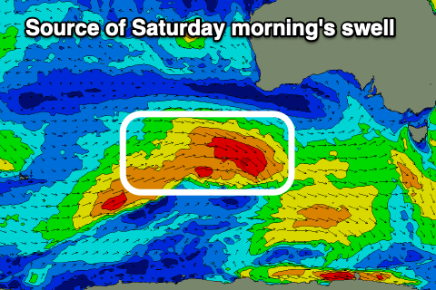
A secondary, stronger frontal system moving in from the south-west of Western Australia should produce a stronger pulse for Saturday morning more to 3ft to occasionally 4ft on the Surf Coast and 6ft to the east, easing through the day.
Winds look favourable for both regions and variable into Saturday morning (tending W/NW on the Surf Coast) before S/SW breezes develop into the early afternoon.
Our third and final pulse of stronger groundswell for Sunday is still on track with a strong low due to move in behind the first two systems, generating a great fetch of severe-gale W/NW winds on top of an already active sea state.
This should produce a moderate to large sized W/SW groundswell for Sunday, possibly a little undersized at dawn but quickly kicking to 4-5ft+ on the Surf Coast with 6-8ft sets to the east.

Local winds look best for the Surf Coast and light W/NW through the morning before shifting S/SW later morning and freshening from the S-S/SE into the afternoon/evening.
Monday will unfortunately see fresh S’ly winds persisting as the swell eases, so make the most of Sunday morning.
A rapid improvement in local conditions is likely on Tuesday as the trough linked to Sunday’s change pushes east, allowing winds to swing around the NE, moderate to fresh in nature.
This will be with fun, easing levels of SW and weak SE windswell. More on this Friday.


Comments
Autumn is that you ?
SW swell/ NW winds.... I think it could be the arrival of Autumn surf conditions at last !
Very fun over east mid-morning. With the conditions and warm weather it felt like autumn is months away.