The beaches continue to be the pick
Victorian Forecast by Craig Brokensha (issued Wednesday August 14th)
Best Days: Today exposed beaches, tomorrow, Friday morning exposed beaches, Monday exposed breaks
Features of the Forecast (tl;dr)
- Small-moderate sized W'ly swell for later this PM, peaking tomorrow AM with local offshore tending N/NE winds while freshening
- Easing swell Fri with strong N-N/NE winds
- Tiny Sat with N/NW-NW tending S/SW winds, strengthening later
- Poor localised S windswell Sun with strong S/SW winds
- Easing windswell Mon, with a new, small-moderate sized W/SW groundswell with E/NE-NE winds
- Easing swell Tue with N/NW winds
Recap
The surf was slow and small to tiny across the Surf Coast yesterday with 1-2ft sets across 13th Beach, while to the east windy 3-4ft sets were seen, best early and late with the tide.
This morning winds are a bit better across the exposed beaches with an inconsistent W’ly groundswell to 4ft on the sets, 1-2ft on the Surf Coast magnets. Winds will go more NE into the afternoon favouring the exposed beaches all day.

Small, clean swell this morning
This week and next (Aug 15 - 23)
Into this afternoon and more so tomorrow, our better pulse of mid-period W’ly swell is due to fill in, generated by a strong frontal system pushing under Western Australia earlier in the week.
This should provide a little more size to the Surf Coast magnets to 2ft to occasionally 3ft with 4-5ft+ sets to the east, peaking tomorrow morning and then easing later in the day.
Conditions will be great with light, local offshore winds, tending N/NE into the afternoon and freshening.

As the swell eases Friday, strong N-N/NE winds will again favour the exposed beaches with easing 2ft sets max on the Surf Coast magnets, 3-4ft to the east.
Moving into the weekend and a broad but weak low moving in from the west looks to be generally poor for swell production, with the swell generating winds on its western flank being more S/SE than anything. The swell looks to also arrive after an onshore change Saturday afternoon.
In general we’ll see no real size across both regions besides some weak, localised windswell.
It looks like NW winds will create clean conditions on Saturday morning but with tiny surf, shifting gusty S/SW into the afternoon and then strong S/SW through Sunday along with a poor increase in localised swell.
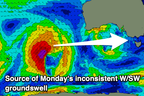
With the low clearing east early next week, winds are due to shift quickly back to the NE on Monday along with a new pulse of long-range W’ly groundswell.

This swell is being generated by a tight low that’s formed south-east of Madagascar and is moving east while generating a fetch of severe-gale to storm-force W/SW winds.
A secondary but less favourably aligned intensification as it moves closer towards Western Australia should help produce a bit of extra size.
It’ll be inconsistent but the Surf Coast magnets should offer 2-3ft sets with 4-5ft+ waves to the east, easing into Tuesday along with stronger N tending N/NW winds.
Longer term, another mid-latitude low moving in from the west may bring some small W’ly swell Wednesday, followed by more promising frontal activity later week. More on this Friday.


Comments
Craig any chance of one decent swell before the end of winter for the surf coast?
I interpreted the below article as things potentially starting to get better for in early Sep. Fingers crossed.
"[Long wave trough node] expected to remain in [Indian Ocean] for the coming fortnight or so before slowly moving east towards the end of the month and hopefully more towards the southeast of the country into September."
https://www.swellnet.com/news/swellnet-analysis/2024/08/08/stratospheric...
Thanks Pngy. Yeah I read that yesterday. Hopefully improvement on the way.
This August weather is divine, completely out of season, the lawn has gone bezerk. Woolies crew packing 'em daily
It's truly out of season and so nice. Small shaped beachies on this side too, great summer fun.
Is this part of haywire weather around the globe Craig? I see Europe is on an Australian-style series of heatwaves. It's pretty good down here even if so.
West Coast sandbank I surfed on my lonesome today whisked me off to the Pass in Byron it was so ruler edge and long walled.
Thigh to Shoulder peelers for hours.
With the smell of zinc cream on my nose and the balmy north wind I swear it was summer. but no one else around.
The long range models look worse for the majority of vicco than what we are currently enjoying. Enjoy these sunny warm offshore beachies and select magnet reefs while ya can. Better than a sloppy wsw wind with 3ft of swell and endless cloudy days. Some of the activity pointed out above is very unlikely to be anything worthwhile just short-range south or SE swell even depending on how it cuts across the country.
Hey Swellnet, any reason why the camera at Fairhaven has been down for so long?