A couple of windows to work this week
Victorian Forecast by Craig Brokensha (issued Monday May 20th)
Best Days: Wednesday morning, Friday ahead of the change, Saturday morning
Features of the Forecast (tl;dr)
- Easing swell tomorrow AM with mod-fresh S winds
- Moderate sized S/SW groundswell for later tomorrow, easing quickly Wed with W/NW tending S/SW winds
- Smaller Thu with W/NW tending S/SE winds
- Moderate sized mid-period SW swell building Fri with W/NW tending S/SE winds around midday
- Easing swell Sat with E/NE-N/NE winds
Recap
Our secondary large pulse of S/SW groundswell due Saturday came in on cue but so did the onshore winds, creating average to poor conditions across most locations. Protected spots faired best for the savvy, while yesterday morning was cleaner but smaller and back to 2-3ft on the Surf Coast.
The surf improved through the day though as a moderate sized mid-period SW swell started to build along with winds remaining favourable until early afternoon.
The frontal system linked to this swell brought the change into the afternoon, with S’ly winds lingering into today with moderate levels of swell.
This week and weekend (May 21 - 26)
Fits and spurts.
It seems the tend at the moment with a couple of pumping days followed by onshores and a return to the easterly pattern.

Following late, last week’s pumping surf, the coming period looks a bit more hit and miss.
Tomorrow will remain onshore with moderate to fresh S’ly wind along with a drop in size from today.
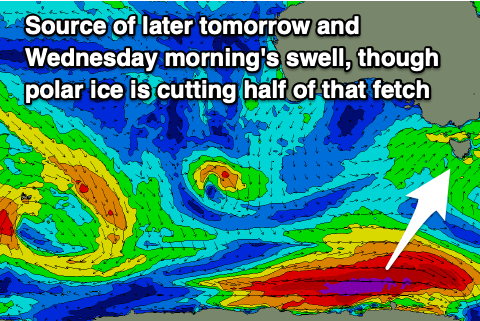
A new pulse of S/SW groundswell due into later tomorrow afternoon and Wednesday morning looks to have been downgraded a little thanks to the polar low linked to it forming a little later and further east in our swell window.
We should still see a good pulse of energy for Wednesday morning though, coming in at 3ft to occasionally 4ft across the Surf Coast at dawn (easing steadily) along with a morning W/NW breeze. This is a window worth making the most of, with easing swell and S/SW winds due into the afternoon, smaller Thursday but clean again with a morning WNW breeze again.
Friday is a tricky one, with the swell due to start small with an early W/NW breeze, though a trough will bring a fresh S/SE change during the day, likely by midday. A new pulse of mid-period SW swell is due to fill in through the day and the timing between the building size and change will be key.

The source is a relatively weak but healthy polar low moving under the country over the coming days, generating a fetch of strong to near-gale-force W/SW winds. The swell should build to the 4ft range across the Surf Coast magnets into the afternoon, 6ft to the east, then ease Saturday with what looks to be a swing in winds back to the E/NE-N/NE.
This will favour the beaches with easing 3ft sets on the Surf Coast and 4-5ft to the east.
From here on in we’re looking at a good run for the exposed breaks across the region with persistent winds from the north-eastern quadrant along with small to moderate levels of long-range W/SW groundswell. More on this Wednesday.


Comments
"This week and weekend (Apr 21 - 26)" ?
Agh. fixed.