Slow improvement in surf and winds from mid-week
Victoria Forecast by Craig Brokensha (issued Monday 13th July)
Best Days: Beaches for keen surfers Wednesday morning and Thursday, Friday on the beaches, Saturday, Sunday Surf Coast
Recap
Clean and fun waves across the magnets on Saturday morning with a background swell to 2ft+ on the Surf Coast with a bit more size to the east. Sunday was average with an onshore wind and small swell.
Today fresher onshore SE winds have kicked in creating choppy conditions with a mix of small SE windswell and background groundswell.
This week and weekend (Jul 14 - 19)
These notes will be brief as Ben's on annual leave.
Tomorrow will be another lay day with moderate to fresh SE winds and a continuation of junky and likely a little more sizey SE windswell and background long-period W/SW groundswell. The SE windswell looks to provide the most size, but exposed beaches on the Mornington Peninsula should see inconsistent 4ft sets, similar Wednesday morning.
Winds are expected to improve slowly and swing E/SE-E Wednesday morning, favouring selected spots east of Melbourne.
A temporary low point in size is due Thursday morning, back to 1-2ft or so on the Surf Coast, 3-4ft to the east, but our new and better long-period W/SW groundswell for the afternoon is still on track.
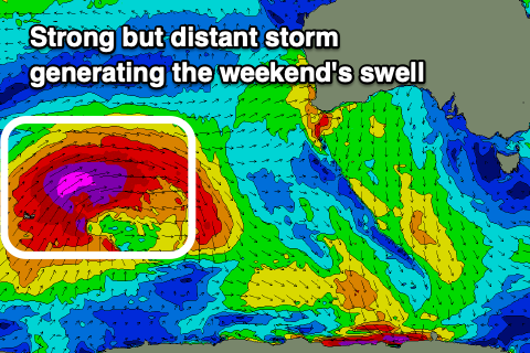
This began being generated late last week by a storm forming around the Heard Island region, projecting a fetch of severe-gale W/SW winds up towards WA and then Indonesia. While not ideally through our swell window we should still see a fun kick in inconsistent size later Thursday and peaking Friday morning to 2-3ft on the Surf Coast magnets, 4-5ft+ to the east.
 Winds on Thursday will continue to improve, swinging light E'ly and possibly even being variable on the Surf Coast, giving into weak SE sea breezes, but Friday is the pick with a persistent N/NE offshore.
Moving into the weekend, the secondary pulse of long-period and inconsistent W/SW groundswell is also on target.
The storm generating this swell will be a touch stronger but follow a similar track to the one generating Friday's swell.
As a result we'll see a similar inconsistent but stronger W/SW groundswell building Saturday and either peaking later in the day or early Sunday. Infrequent 3ft waves are due across most locations on the Surf Coast with 4ft sets on the swell magnets, 5-6ft to the east. Expect long waits for the sets though.
Winds will strengthen though but hold from the N'th Saturday and then swing N/NW on Sunday ahead of an approaching mid-latitude front. The front is forecast to develop into a low on approach to us Sunday, bringing a moderate sized increase in windy SW swell early next week but with poor winds. More on this Wednesday.


Comments
crap wish we could travel to NSW/QLD!!!!
worst winter in ages
Seems a miracle to have anything over 3ft.... Probably one mid sized swell with good wind since the start of actual winter. >:(
We are getting the summer conditions we missed out on this year in the east, best winter in ages! Such a bizarre winter. You could drop these notes into mid Feb and it wouldn’t look out of place
I accept this
This forecast should keep some of the Rona Couriers in town.
Somebody was done for driving from city to Mornington to walk their dog. I reckon good chance cops won’t accept exercise excuse so good luck city crew if you want to head down the MP
I'd say it's hard to justify walking your dog when you can do that in your area! As surfing is still permitted as a sport/exercise and the MP being the only place to surf, cops don't really have any grounds to fine you.
Yep, and 2 active cases in 2 days down here now. I wonder where they came from. Need to lock it down
Well, one of them was a staff member of the Mornington Telstra store so that's a pretty long bow if you're suggesting it was brought down from the city.
Anyway the banks are shit on the MP at the moment