Mostly onshore this coming period with a large swell
Victoria Forecast by Craig Brokensha (issued Wednesday 20th May)
Best Days: Protected spots tomorrow afternoon and Friday
Recap
The final pulse of inconsistent W/SW groundswell for later Monday and yesterday morning came in a little undercooked, with me getting a little too excited seeing the over-performance of the swells through Sunday and Monday morning. Instead we saw inconsistent 3ft waves on the Surf Coast and 4-5ft+ waves to the east but with favourable conditions for the beaches all day.
This morning winds have shifted and conditions are deteriorating on the Mornington Peninsula with easing 4-5ft sets, 2-3ft on the Surf Coast and inconsistent. We'll see the swell easing slowly through the day as winds hold from the NW, even possibly shifting N/NW.
This week and next (May 21 - 29)
The pre-frontal NW winds through today will shift to a strong onshore S/SW change early tomorrow morning, creating poor conditions across all locations as a new S/SW groundswell builds.
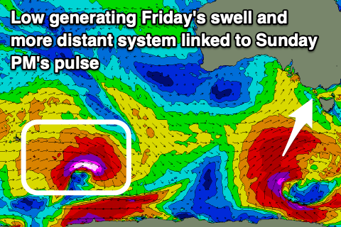
The source of the groundswell is a fetch of S/SW gales at the base of the front bringing the change tomorrow, while this will be part of a broader and stronger polar low developing south-west of Tassie today.
While both coasts are due to be on the small and weak side tomorrow morning, we should see strong 4ft+ surf developing across the Surf Coast into the afternoon, 6ft+ to the east as winds shift SW but remain strong.
 The polar low will generate a broader and stronger fetch of gale to severe-gale SW winds through our southern swell window today and early tomorrow before the low pushes further east tomorrow afternoon.
A larger S/SW groundswell will result and fill in Friday providing easy 6ft sets on the Surf Coast, 8ft+ to the east. Winds should swing back to the W/NW across the Surf Coast through the morning though there'll likely be leftover lump from tomorrow's onshore winds.
Winds will shift S'ly through the day though so aim for a morning paddle.
The weekend still looks poor with a high moving in from the west due to be squeezed by a low in the Tasman Sea, bringing moderate to fresh and strengthening S'ly winds Saturday, moderate out of the S/SE on Sunday.
The swell is likely to still be large early Saturday out of the S/SW but easing steadily from 4-5ft+ and 6ft+ respectively on the Surf Coast and Mornington Peninsula. On Sunday a new inconsistent SW groundswell is expected from a strong polar low drifting south-east through our far swell window, south-west of WA. While inconsistent it should provide 3ft+ sets on the Surf Coast Sunday afternoon as it peaks, 4-5ft+ to the east. Conditions will be average with those onshore winds though.
The models diverge into early next week and this revolves around the longevity of the low in the Tasman Sea and possibly re-intensification. If this happens we'll see winds persist onshore from the SE into Monday, likely swinging back offshore Tuesday as a mid-latitude low approaches from the west (forecast by all models).
This looks to be the start of a significant Southern Ocean frontal progression under the influence of strong node of the Long Wave Trough. More on this Friday though.

