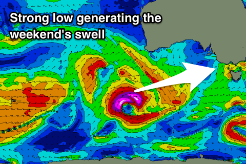
Improved forecast for the weekend
Victoria Forecast by Craig Brokensha (issued Wednesday 31st May)
Best Days: Friday, Saturday morning and Sunday morning on the beaches, Monday morning
Recap
Clean though inconsistent waves to 2ft across magnets on the Surf Coast yesterday morning, building a touch into the afternoon as winds shifted more W'ly with an approaching front.
This front came in a little stronger than forecast as it pushed through Bass Strait last night, generating a bit more size than expected this morning with good clean 3-4ft reef waves on the Surf Coast, and 6ft surf to the east. Winds should hold from the W/NW all day as the swell eases.
Today’s Forecaster Notes are brought to you by Rip Curl
This week and weekend (May 31 – Jun 3)
With last night's front being upgraded in strength while pushing through our swell window, a strong mid-latitude system that's currently pushing in from the west (linked to a new W/SW groundswell tomorrow afternoon and Friday morning) will also come in a touch stronger than forecast on Monday.
We'll see this front push through overnight, kicking up some new weak mid-period W/SW swell tomorrow morning to 3ft on the Surf Coast and 4-5ft+ on the Mornington Peninsula.
The groundswell will fill in slowly through the day and provide stronger though similar sized sets, easing back from the 3ft range Friday morning on the Surf Coast and 4-6ft to the east.
Winds are an issue tomorrow with a fresh to strong SW'ly, possibly W'ly for a brief period early around Torquay.
Friday looks better with a light variable breeze across all locations creating improving conditions, with weak early-mid afternoon sea breezes.
The weekend forecast is looking a little more positive as well, with a good long-period SW groundswell due to fill in with favourable winds for the more exposed beaches.
 The unconsolidated and patchy frontal activity occurring south-west of Western Australia is still that, but we'll see an intense and slow moving low generating a right fetch of severe-gale to storm-force W/SW winds in our western and then south-western swell window from this afternoon through tomorrow evening.
This will generate a moderate sized long-period W/SW tending SW groundswell that should arrive Saturday morning and build to 3-4ft on the Surf Coast into the afternoon and 6ft+ to the east.
The easing trend will be slowed owing to the prolonged nature of the low, with Sunday dropping from 3ft+ and 5-6ft respectively.
Winds are now looking best for the beaches, with a morning E/NE-NE breeze Saturday ahead of afternoon SE winds, similar Sunday as the swell eases. Sunday morning may see a touch more north in the winds for the Surf Coast, but we'll have to review this Friday.
Monday morning looks cleaner on the Surf Coast, with a low point in swell ahead of some new inconsistent W/SW energy into the afternoon and Tuesday. We'll have a closer look at this Friday though.


Comments
Yes. Talk dirty too me Craigo..
Haha, Gary...
Hi Crag
Gary wants to know whether you've ever fallen foul of the law, having your gherkin all out on public display there?
Asking for a friend.
Excited when Craig's words help you imagine yourself straddling the top of the dunes with a straight, firm swell penetrating your coastline in all the right ways, Nick B?
Made all the sweeter by the tales of a gentle breeze blowing sweet nothings across the back of your ears: "Just relax, Nicky boy, imma give you the time of your life".
Craig Friday. E. NNW. E
Will be a very rare event.
Ahhhhh, classic Very Vicco Conditions Eh?? BiG. PhaT. CoLD & Heavy Long-Range Sets Rollin' on in...where boys & men are seperated like the wheat from the chaff ;-) Enjoy the weekend...should be some mystery reefs firing away.