Lower-range swell pulses, clean most mornings
Victoria Forecast by Craig Brokensha (issued Monday 28th May)
Best Days: Tuesday magnets Surf Coast, Wednesday morning Surf Coast, Surf Coast Friday, and Sunday morning
Recap
Fun waves across both coasts on Saturday with clean easing 2-3ft sets on the Surf Coast and 3-4ft waves to the east, small to tiny into Sunday.
Today the swell has bottomed out with the Mornington Peninsula the only option for a wave.
Today’s Forecaster Notes are brought to you by Rip Curl
This week and weekend (May 29 – Jun 3)
With the swell bottoming out today, we look towards tomorrow's mix of long-range and inconsistent SW groundswell, mixed in with a closer-range and now weaker W/SW swell.
The long-range energy looks best now, with the tight mid-latitude low that was forecast to develop yesterday only generating a weak fetch of short-lived strong to gale-force W/SW winds while dipping south-east through our swell window.
 What's now expected tomorrow is inconsistent 2ft to maybe 3ft sets across the Surf Coast through the day, with 3-5ft sets to the east, with the afternoon seeing the small W/SW swell to a similar if not slightly smaller size.
Winds will do a rotation from an early fresh and gusty N'ly, to the NW through the morning, W/NW early afternoon and then W/SW change mid-afternoon.
Both swells are due to ease through Wednesday under a persistent W/NW wind, favouring the Surf Coast but we're only looking at surf to 2ft to maybe 3ft again.
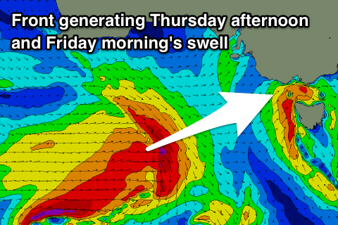
Moving into Thursday and a fun new W/SW groundswell should build through the day, generated by a strengthening front passing under WA tomorrow, projecting a fetch of W/SW gales through our western swell window.
The remnants of this front will actually move through Wednesday evening and bring poor winds into Thursday, fresh to strong from the SW, easing through the day. Torquay may see an early W'ly but the swell will still be maturing and not great, likely to 2-3ft max early, but a better 3ft into the afternoon. The Mornington Peninsula looks to build to 4-5ft+.
Friday is looking better as the swells ease back from a similar size range on both coasts with a W/NW offshore, possibly variable into the afternoon.
The weekend is looking a little hit and miss with favourable offshore NW winds for the Surf Coast and flukey small W/SW swells.
There's a bit of action occurring south and south-west of WA through the end of this week but it's all patchy with no real consolidation.
We're looking at small surf in the 2ft range on the Surf Coast, maybe a touch stronger and near 2-3ft on Sunday, but we'll have a closer look at this on Wednesday.
Longer term there's still no major storm activity in our swell window, but check back on this Wednesday.


Comments
Craig who is the Local Surf Reporter 4 Torquay? He’s a GUN.
Nice though inconsistent lines at 13th Beach.
Weekends looking better for MP. Light winds atleast. Will i have too continue to sacrifice goats i wonder?
Yeah and Saturday afternoon's swell is much better. 3-4ft Surf Coast and 6ft MP.
Will that swell carry through to Sunday Craig?
I noticed the models updated today moving the new swell to the evening but at 16secs it looks to be better than expected!
Yeah, easing from a touch less size than later Saturday.