Small weekend with favourable winds for the beaches, mixed next week
Victoria Forecast by Craig Brokensha (issued Friday 25th May)
Best Days: Exposed beaches Saturday, swell magnets Sunday, Surf Coast Tuesday afternoon
Recap
Clean waves waves yesterday morning on the Surf Coast in the 3ft range before an onshore change moved through along with some new building S/SW groundswell which peaked overnight.
This morning though we've still got strong lined up 4-5ft sets on the Surf Coast with improving conditions under an early but easing onshore wind that's tended variable creating glassy surf. Locations to the east are a bit cleaner but still mostly too big.
Today’s Forecaster Notes are brought to you by Rip Curl
This weekend and next week (May 26 – Jun 1)
We'll see this morning's strong S/SW groundswell easing through today and much more rapidly through tomorrow in the wake of the strong low generating the swell pushing out of our swell window early Thursday morning.
The Surf Coast should ease back from 2ft+ with 3ft to maybe 4ft sets to the east under a local offshore northerly winds, tending variable into the afternoon.
Our small pulse of S/SW groundswell for Sunday of a weak polar low that's currently south-southwest of Tassie doesn't look to provide much size at all, with an inconsistent 2ft due to develop on the Surf Coast into the afternoon (smaller early) and 3ft sets to the east after lunch.
Winds look to favour swell magnets all day, being fresh from the N/NE.
 Moving into Monday and a severe low that's currently off the south-west of WA is now sitting too far north to generate any decent W'ly swell for us Monday with tiny waves due across the Surf Coast and small leftover surf to maybe 2ft on the Mornington Peninsula under a gusty N'ly wind.
On Tuesday some new long-period and inconsistent W/SW groundswell from a strong but distant polar low that developed in the south-east Indian Ocean yesterday.
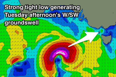
Only small and inconsistent surf is due, especially on the Surf Coast, with infrequent sets to 2ft+, bigger and to 3-5ft to the east, but into the afternoon a better W/SW swell is due from a low forming under the Bight on Sunday evening.
A fetch of gale to severe-gale W/SW winds should be aimed through our western swell window, generating a better W/SW groundswell pulse for the afternoon, reaching 3ft+ on the Surf Coast and 5-6ft on the Mornington Peninsula with gusty N/NW tending W/NW winds.
The swell looks to ease back through Wednesday but another small low moving across us may bring onshore winds at dawn from the S/SW, improving into the afternoon. The models still diverge around this, and patchy following systems (mostly likely westerly swell with average winds), so we'll have to have a closer look on what mid-late next week looks like on Monday.
Have a great weekend!


Comments
Haha. What a fucking slap in the face for us on the peninsula. Since when do storms dissappear in Bass Strait.
What's up Nick?
The weekend looked so good at start of the week then ZAP! Bye bye swell. Just a huge mutha fruitin tease as we exit the 2 week WSW wind tunnel.
Hey craig so how big do you reacon the waves will be tomorrow on the morrington peninsula
Did you not read the notes above?
was a weird week on the surf coast, good swells but never really quite offshore - a couple of places were working but needed to go for a bit of a drive
Tasty bowls at Woolamai this arvo.
