Large south swells all week and weekend
Victoria Forecast by Craig Brokensha (issued Monday 21st May)
Best Days: Surf Coast every morning, locations to the east on the weekend
Recap
Good clean waves on the Surf Coast reefs most of the weekend, around the 3ft range Saturday and 3-4ft Sunday morning, with a bit more size later in the day.
This morning a mix of swells is providing good 3-5ft waves on the Surf Coast again, best in protected spots with large messy surf to the east.
Today’s Forecaster Notes are brought to you by Rip Curl
This week and weekend (May 22 - 27)
As touched on in last week's notes, we've got plenty of swell on the way for the coming period as a strong node of the Long Wave Trough sits across the Tasman Sea, moving slowly east through this week as another node in the Indian Ocean starts encroaching from the west.
The node to our east is directing a series of vigorous polar storms up through our swell window, with a great looking system currently south of the country, generating W/SW gales.
We'll see this front projected up towards Tassie while strengthening in our southern swell window, producing a moderate to large sized S/SW groundswell for later tomorrow and more so Wednesday morning.
Tomorrow a mix of mid-period swells should keep the Surf Coast around 3-5ft most of tomorrow, and 6ft+ to the east, increasing a little later with the new swell.
Winds will be generally poor and gusty from the W/SW, better and from the W/NW early around Torquay.
 Wednesday morning looks excellent for the reefs with offshore W/NW winds, tending W-W/SW through the afternoon and with the S/SW groundswell easing from 4-5ft+ on the Surf Coast, with 6ft+ sets to the east.
A temporary low point in swell is expected early Thursday ahead of a new long-period S/SW groundswell through the afternoon, generated by a tight and very intense polar low forming under the country tomorrow afternoon.
A fetch of severe-gale to storm-force SW winds will be generated in our southern swell window, generating a large long-period S/SW groundswell that should kick wave heights back to 5-6ft on the Surf Coast magnets through the afternoon, 6-8ft to the east.
Winds look favourable for the Surf Coast through the morning and from the W/NW, swinging onshore S/SW into the wake of the system generating the new swell.
Friday morning should become clean again but with easing 3-5ft waves on the Surf Coast, 6ft+ to the east with a W/NW breeze, giving into another onshore change late morning.
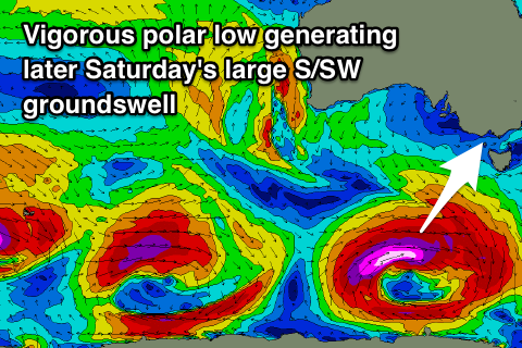
Saturday will see the swell continuing to ease, but yet another vigorous polar low is set to generate another large long-period S/SW groundswell for later in the day and Sunday morning.
We're looking at 5-6ft surf late in the day on the Surf Coast reefs, 6-8ft to the east, easing back through Sunday along with favourable local offshore winds Saturday morning, N-N/NW on Sunday.
Following this we'll see swells arriving from the W/SW owing to the action in the Indian Ocean, but more on this Wednesday.


Comments
It aint bright but it seems like a dim light at the end of the ongoing tunnel
Insides has a cooking right into De Hairs corner, board snapping Dog style.
It will keep you entertained for the time being. Mr. Bone
Hi Craig, what has happened to Saturday's swell? Seems to have evaporated off all the charts?...
Ah wow yeah the models have weakened off the third low.
Swell looks to be for Sunday morning and only 2-3ft Surf Coast, 4ft+ to the east now.
Thanks Craig