Moderate swell pulses all week, cleanest to the west each morning
Victoria Forecast by Craig Brokensha (issued Monday 2nd April)
Best Days: Surf Coast Tuesday morning, Wednesday morning, Thursday morning and Friday morning, exposed beaches Saturday morning
Recap
Saturday's reinforcing SW groundswell came in a little over expectations with solid clean 4-6ft surf across the Surf Coast, larger to the east and with favourable winds all morning and early afternoon before sea breezes picked up.
Sunday was smaller but clean across all locations with easing 3ft+ waves on the Surf Coast, and 4-5ft+ on the Mornington Peninsula.
Today a new W/SW groundswell has filed in, generated by a strong low pushing in under the country over the weekend, projecting a fetch of severe-gale W/SW winds through our western swell window.
This swell, has come in at a solid 3-5ft on the Surf Coast (with the odd bigger bomb at magnets) and 6ft+ on the Mornington Peninsula with early W/NW winds, which have now shifted back onshore.
Today’s Forecaster Notes are brought to you by Rip Curl
This week and weekend (Apr 3 - 8)
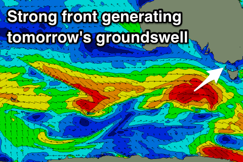
Today's pulse of W/SW groundswell will be backed up by a secondary similar sized pulse of W/SW groundswell tomorrow morning, generated by a secondary vigorous front pushing in behind the system over the weekend, generating a fetch of W/SW gales on top an active sea state.
 This should produce a moderate to large sized W/SW groundswell coming in at 4-5ft+ across the Surf Coast swell magnets tomorrow morning (3-5ft most other breaks) and 6-8ft on the Mornington Peninsula, easing through the day. An early W/NW breeze will favour the Surf Coast reefs again through the morning before shifting W/SW-SW mid-late morning and then S/SE into the afternoon.
The swell is due to steady around 3-4ft at magnets on the Surf Coast Wednesday and 6ft on the Mornington Peninsula as weaker persistent fronts pushing in from the west generate reinforcing swells.
Winds on Wednesday look to be a little funky and variable though likely light from the W/NW on the Surf Coast through the morning ahead of sea breezes.
From Thursday morning we're due to see the swell slowly drop away owing to the storm activity easing through our swell window. The Surf Coast looks to ease slowly from 3ft to possible 4ft with 4-6ft sets on the Mornington Peninsula, smaller Friday from 3ft max on the sets west of Melbourne, 4-5ft to the east.
Conditions will be best on the Surf Coast both Thursday and Friday with a light morning W/NW breeze on the former, and a light NW wind Friday morning.
Into the weekend no new swell is due but light NE winds should favour the exposed beaches while an onshore change is due Sunday. More on this in Wednesday's update though.

