Large onshore surf tomorrow, improving across the beaches from Thursday
Victoria Forecast by Craig Brokensha (issued Monday 19th March)
Best Days: East of Melbourne Thursday and Friday mornings, swell magnets Saturday morning
Recap
Pumping waves across both coasts Saturday with Friday's large kick in S/SW groundswell still coming in at 3-4ft on the Surf Coast and 4-6ft on the Mornington Peninsula with all day offshores.
Sunday was poor with no swell and strong offshore winds.
Later in the day some stormy W'ly swell build, coming in this morning at a smallish 2-3ft on the Surf Coast and bumpy 4-5ft on the Mornington Peninsula, but we're due to see some stronger W/SW groundswell building through the day as winds hold from the W-W/NW.
We should see sets hitting 6ft at magnets on the Surf Coast later today and 8ft on the Mornington Peninsula, cleanest in protected spots.
Today’s Forecaster Notes are brought to you by Rip Curl
This week and next weekend (Mar 20 - 25)
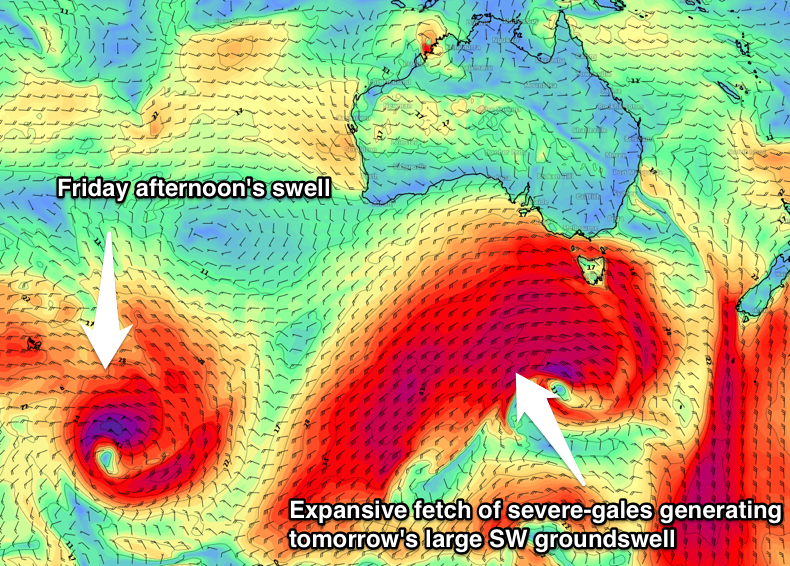
This afternoon's first pulse of large strong W/SW groundswell was generated over the weekend by a vigorous mid-latitude front racing under the Bight, projecting a fetch of severe-gale W'ly winds on top an active sea state.
Following right behind this system is an elongated fetch of gale to severe-gale W/SW winds, extending from south-southwest of WA on the polar shelf, all the way up to our state.
 This fetch is again working on top an already active sea state and projecting slightly towards us resulting in a very large SW groundswell tomorrow.
We should see the Surf Coast coming in around 8ft across magnets all of tomorrow, with 10ft+ surf on the Mornington Peninsula, though winds are looking poor. As touched on last week, a strong high will move in quickly from the west bringing gusty SW tending S/SE winds.
There's only a slim chance of early W/SW breezes around Torquay and with the large agitated sea state it will be raw and victory as sea conditions.
Wednesday will see the swell easing back from a large 5-6ft+ on the Surf Coast and 8ft on the Mornington Peninsula but with poor and gusty E/SE winds. This will whip up a junky windswell on the Surf Coast as the groundswell eases.
Into Thursday and Friday we'll see slightly better E/NE and NE winds respectively creating good conditions on the Mornington Peninsula.
The swell will be on the ease Thursday from 4-5ft, (3ft on the Surf Coast), but Friday a new long-period and inconsistent SW groundswell is due.
This is currently being generated by a tight and intense polar low that's currently east of Heard Island. A fetch of severe-gale to storm-force W'ly winds should produce a good but inconsistent groundswell that will arrive during the morning and build through the day ahead of a peak in the afternoon.
The Surf Coast should build to a good 3ft, with 4-5ft+ sets on the Mornington Peninsula under that favourable NE-N/NE breeze. Winds are likely to go sea breezey, but more so mid-afternoon.
The weekend will see the groundswell ease under offshore N'ly winds Saturday, onshore and tiny Sunday, but more on this in the next update.

