Large S/SW groundswell Friday with improving winds, clean and easing Saturday
Victoria Forecast by Craig Brokensha (issued Wednesday 14th March)
Best Days: Surf Coast Thursday morning, both coasts Friday morning and Saturday
Recap
Large messy surf across all locations yesterday, improving a little into the afternoon as onshore winds eased.
This morning conditions were a bit better again with onshore winds continuing but with less strength and a touch less swell. The protected reefs on the Surf Coast and Phillip Island have provided fun waves for keen surfers.
Today’s Forecaster Notes are brought to you by Rip Curl
This week and weekend (Mar 15 - 18)
We've seen two strong pulses of SW groundswell over the past two days, the first for later Monday and yesterday morning, with a new pulse for today.
We've got a third due later today and tomorrow morning, produced by a good fetch of W'ly gales moving in on top of all the frontal activity earlier this week.
We should see the Surf Coast hanging in around 3ft to occasionally 4ft tomorrow morning with 5-6ft sets on the Mornington Peninsula.
Conditions should be cleaner again on the Surf Coast with a light morning W/NW breeze tending SW late morning.
 The swell is due to ease through the day, ahead of some new S/SW groundswell late, but more so Friday.
Last night a vigorous polar low formed south-west of Tasmania, with a fetch of severe-gale W/SW winds already being generated in our southern swell window. There are a couple of 50kt barbs in the mix as well, and we'll see this low project similar strength severe-gale to storm-force winds north-east through our southern swell window today, producing a large long-period S/SW groundswell.
This swell is due to peak Friday morning to a large 5-6ft on the sets across the Surf Coast and 8ft on the Mornington Peninsula, easing slowly through the afternoon and more noticeably Saturday from 3ft+ and 5ft respectively.
Winds are now looking better on Friday as a trough races in from the west resulting in light NE tending variable N winds, ahead of mid-afternoon sea breezes. This should create improving conditions across both regions during the day.
As the swell eases Saturday conditions look good across most spots with a moderate to fresh N'ly tending N/NW breeze.
Sunday looks average as the swell continues to fade under a strengthening NW tending W'ly breeze.
Next week onwards (Mar 19 onwards)
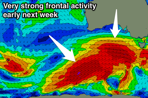
As touched on last update, another strong node of the Long Wave Trough is forecast to move in towards us over the weekend and with this we're due to see an even stronger and broader flurry of frontal activity compared to this week.
With this we're due to see a large powerful W/SW-SW groundswells from later Monday through Tuesday/Wednesday next week with winds from the western quadrant. More on this Friday though.

