Good S/SW groundswell for Thursday with decent winds for the beaches
Victoria Forecast by Craig Brokensha (issued Monday 5th March)
Best Days: Swell magnets Wednesday morning, beaches east of Melbourne Thursday morning, Friday morning, swell magnets Saturday morning
Recap
Great waves across all regions on Saturday morning with a new longer-period SW groundswell and favourable winds until early/mid afternoon.
Sunday was then poor with smaller amounts of choppy swell.
Today a new W/SW swell from the front pushing through yesterday has kicked up a bit of energy across both coasts, but conditions are again poor with fresh onshore winds.
Today’s Forecaster Notes are brought to you by Rip Curl
This week and weekend (Mar 6 - 11)
Today's increase in W/SW swell is due to ease through tomorrow, with no real size left into Wednesday as winds swing offshore.
Tomorrow we'll see a poor mix of easing W/SW swell and building SE windswell with easing 2ft waves on the Surf Coast and 3-4ft sets to the east. A moderate to fresh SE wind will create poor conditions.
Wednesday should see E/NE tending N/NE winds through the morning, but the Surf Coast looks tiny and fading from 1-1.5ft max, while the Mornington Peninsula should see 2ft to maybe 3ft sets early, smaller later.
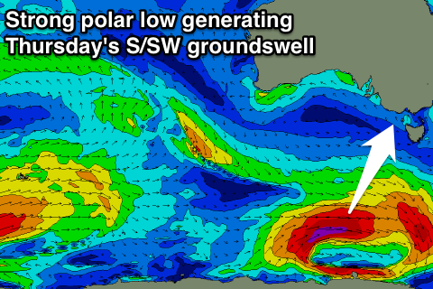
 Our new S/SW groundswell due later in the week has been upgraded, with a strong polar low forming earlier in our swell window.
We'll see a strong polar low forming in our southern swell window this afternoon/evening, with a fetch of severe-gale W/SW winds being projected along the polar shelf before the system moves out of our swell window tomorrow afternoon.
We should see this swell arriving overnight Wednesday and peaking Thursday morning to a good 3ft+ on the Surf Coast and 4-5ft on the Mornington Peninsula. Winds will be from the eastern quadrant, favouring the beaches, with more NE winds on Friday morning as the swell drops back a touch.
A reinforcing S/SW swell from a secondary but tighter and later forming polar low will keep wave heights around 2ft+ on the Surf Coast and 3-4ft to the east.
The weekend is looking small with tiny fading waves on the Surf Coast, best to the east with morning offshores. Come Sunday the swell will bottom out as a change moves through.
This change should signal the start of some stronger storm activity as a node of the Long Wave Trough strengthens over us. We'll see plenty of swell developing for next week, but more on this Wednesday.

