Average period continues
Victoria Forecast by Craig Brokensha (issued Friday 24th November)
Best Days: Wednesday morning and Thursday east of Melbourne
Recap
A little underwhelming yesterday across the Surf Coast, but fun on the beaches to the east with a new inconsistent W/SW swell and light winds, tending offshore.
This morning the swell was a touch smaller and on the ease, with favourable winds across most locations, though we'll see sea breezes develop into the afternoon.
Today’s Forecaster Notes are brought to you by Rip Curl
This weekend and next week (Nov 25 – Dec 1)
If you're looking to surf over the weekend, hit the most exposed spot you can to the south-west tomorrow morning. The surf will remain small to tiny tomorrow, with no decent swell and light variable winds should create clean conditions through the morning before sea breezes kick in.
The Surf Coast is only due to be in the 1-1.5ft range at 13th Beach, with 2ft to maybe 3ft sets on the Mornington Peninsula, easing through the day.
 Come Sunday winds will be average for exposed breaks, with a light W/NW tending SW breeze as a developing trough starts moving in from the west. The swell will also be tiny.
This trough will actually spoil a fun new SW groundswell due through early next week, with onshore S/SW tending S/SE breezes Monday, swinging more E-E/SE and strengthening Tuesday.
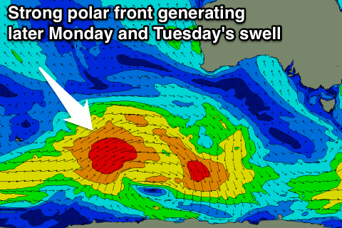
The SW groundswell is currently being generated by a strong polar front that's currently south-west of WA, with a broad fetch of W/SW gales being generated through our swell window.
This front will move eastward while slowly weakening this evening, and further tomorrow as a secondary small polar front moves in.
We should see a fun sized SW groundswell building Monday, reaching 3ft across swell magnets on the Surf Coast late in the day and 4-6ft on the Mornington Peninsula, easing back into Tuesday.
The secondary front will generate a secondary reinforcing swell for Wednesday to 2ft+ on the Surf Coast and 3-5ft on the Mornington Peninsula.
As touched on though, winds will be poor, and strengthening E/SE winds on Tuesday will kick up a similar sized SE windswell to the groundswell across the Surf Coast later in the day, easing back through Wednesday.
Winds are likely to swing more E/NE/NE on Wednesday morning with the mix of SW and SE swells, creating fun waves on the beaches east of Melbourne.
Following this there's nothing significant to follow, with easing surf and offshore N/NE winds to end the week. Have a great weekend!


Comments
Crapola. This is getting ridiculous..
Yeah, spring has really sprung!
I think I was there for the end of it, the Grand Final weekend, jeez that was good!
Craig, as Gary's rig is clearly the most exposed spot in Victoria, Gary would appreciate in future if you asked his permission before advising every surfer in the state to hit it tomorrow morning.
Haha, left that wide open didn't I.
Sensible Vic Surfers have been making the Trek to Woolamai Beach which has been producing outstanding waves. THOSE IN THE KNOW Go where there's waves.
Sensible Vic Surfers Shut there Fucken mouths
Been all time conditions on Torquay golf course this November.
Hey Craig
Although a while out, any news regarding next weekend?
We have the 1st state round organised for Sat/Sun around the Cape Patterson area, Boogie Boarding Vic..
Alot of crew will be travelling and camping would be nice to give some good news or just an update regarding conditions
Cheers
Hi Seaside, here's the latest update.. not the best news.
Great waves developing across the beaches.