Fun waves across exposed breaks over the next two days
Victoria Forecast by Craig Brokensha (issued Wednesday 22nd November)
Best Days: Exposed beaches on both coasts tomorrow morning, exposed beaches east of Melbourne Friday morning, and keen surfers Saturday morning
Recap
No surf across the Surf Coast yesterday and tiny waves to the east with favourable conditions through the morning.
Today a very inconsistent and small W/SW groundswell has provided a bit more energy on the Mornington Peninsula and Phillip Island with 2-3ft sets, but the Surf Coast has remained tiny and to 1ft.
We should see a late increase in stronger W/SW groundswell today, but winds will be onshore and average.
Today’s Forecaster Notes are brought to you by Rip Curl
This week and weekend (Nov 23 - 26)
This morning's small and first pulse of W/SW groundswell is the precursor to a secondary better increase due later today, ahead of a peak early tomorrow.
This next swell isn't anything special and will be just as inconsistent but should provide fun waves across the state tomorrow morning.
There's been no change to Monday's forecast, with infrequent but decent 3ft sets due at exposed beaches to the west swell on the Surf Coast (13th Beach etc), it'll be in the 2ft range at most other breaks and 5-6ft on the sets Mornington Peninsula. The swell will ease through the day, further from an infrequent 2ft on the sets on the Surf Coast magnets Friday morning and 3-4ft to the east.
Winds tomorrow look great for the beaches again with an early light NE breeze, tending more N through the day before sea breezes kick in, and then Friday will see morning variable winds, tending locally offshore before sea breezes develop again.
 Our very slight pulse of SW groundswell for Saturday morning isn't looking too good at all, generated by a very small and tight low passing quickly through our swell window this evening and tomorrow.
The Surf Coast may see 1-1.5ft sets, with 2ft to maybe 3ft sets on the Mornington Peninsula. Winds will be favourable for magnets again with a morning N/NE breeze ahead of afternoon sea breezes, with tiny surf Sunday and a swing in winds to the NW/SW
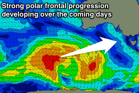
As talked about on Monday, we've got some new swell on the cards for early next week, generated by a decent polar storm firing up south-west of WA tomorrow.
A moderate sized SW groundswell is currently expected off this progression, building Monday and peaking Tuesday though winds are looking less than ideal and likely onshore at this stage. We'll have a closer look at this Friday though.


Comments
Looking fairly forgettable on the Surf Coast this morning, but good on the Mornington Peninsula