Hit the exposed breaks
Victoria Forecast by Craig Brokensha (issued Monday 13th November)
Best Days: Exposed beaches Monday and Tuesday morning, exposed beaches Sunday morning
Recap
Friday's kick in swell eased slowly through the weekend, though conditions were only really decent across the beaches east of Melbourne, and still it wasn't ideal. Saturday offered a bit of size, while Sunday was small.
Today a small inconsistent W/SW groundswell has kept 2ft sets hitting the Surf Coast with variable winds from the east and a better cleaner 3-4ft on the Mornington Peninsula.
This week and weekend (Nov 14 - 19)
As you can probably tell by taking one look at the forecast graph, the coming week isn't too interesting wave wise on the Surf Coast, though exposed beaches across the state should provide fun waves the next two days.
Today's W/SW groundswell was generated by a strong distant mid-latitude low in the south-east Indian Ocean last week, but behind this a much broader and longer-lived but weaker polar front developed.
 This has generated some additional inconsistent W/SW groundswell for the next two days, coming in at an infrequent 2ft on the sets across magnets on the Surf Coast and 3-4ft waves on the Mornington Peninsula.
Conditions will be great for the beaches tomorrow with a N/NE tending variable breeze, while winds should tend N/NW on the Surf Coast through the day. Wednesday looks to play out similar until mid-late afternoon when a W-SW change may be seen.
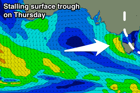
This change will be linked to a surface trough moving in from the west, with it moving in Thursday morning, bringing a S/SW change. At dawn winds might be variable but the swell from the coming two days will be on the way out and fading from 1-2ft on the Surf Coast and 3ft+ to the east.
The trough will stall through Thursday, aiming a strong fetch of S/SE winds through our southern swell window until it weakens Friday. A S/SW windswell will be seen, reaching an easy 3ft across the Surf Coast into the afternoon and 4-5ft on the Mornington Peninsula, easing into Friday.
Winds on Friday are still a little uncertain but we'll likely see onshore SW tending S/SE winds.
The weekend isn't looking too flash with lingering onshore winds and small to tiny amounts of weak swell in the morning Saturday, while into the afternoon a small and inconsistent SW swell is due, peaking Sunday morning.
This swell will be generated by a distant polar low that's currently developed in the Heard Island region, with a slow moving fetch of W/SW gales forecast to be produced in our far swell window.
The swell is only expected to offer infrequent 2ft+ sets Sunday morning on the Surf Coast and 3-4ft+ waves to the east, though winds are likely to tend E/NE. We'll have another look at this Wednesday.

