Improving conditions for the beaches from Thursday
Victoria Forecast by Craig Brokensha (issued Monday 6th November)
Best Days: Keen surfers Thursday morning, beaches Friday, Saturday and early Sunday (keen surfers)
Recap
Not the best weekend of waves with bumpy conditions on the Surf Coast and average conditions also to the east with some small to moderate sized swell.
Today the swell is on the ease and fresh onshore winds are continuing to create poor conditions.
This week and weekend (Nov 7 - 12)
Our current period of average onshore winds looks to continue through most of this week, spoiling a good new S/SW groundswell through late tomorrow and Wednesday.
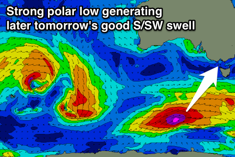
Tomorrow morning will be poor with a small weak windswell and fresh S/SW winds, but a strong new S/SW groundswell is due later in the day, peaking overnight and easing Wednesday.
The swell was and is still being produced by a strong polar low that formed over the weekend, generating a good fetch of gale to severe-gale W/SW tending SW winds while moving through our southern swell window.
 An increase in size us due from about midday, reaching 4ft by dark on the Surf Coast and 6ft on the Mornington Peninsula though with those poor S/SW winds.
A slow drop in size should be seen Wednesday from 3-4ft and 5-6ft respectively but a lingering S/SE wind will continue to create average conditions.
Winds are expected to relax temporarily into Thursday morning but conditions are likely to still be lumpy and far from perfect across both regions. The swell will be smaller and back to 2ft+ on the Surf Coast, with workable 4ft sets on the Mornington Peninsula for keen surfers.
Another good polar low developing through our southern swell window mid-week should produce a fun spike in S/SW groundswell for Friday. The swell may not be in the water at dawn, but should be in by mid-morning, offering 3ft sets across the Surf Coast and 4-5ft waves on the Mornington Peninsula.
Winds will continue to improve, swinging E/NE-NE with an approaching trough, and this will create great waves on the beaches.
Slightly better N/NE winds are due into Saturday as the swell eases, with the exposed beaches across the state due to offer the best waves, dropping from 4ft or so on the sets, small into Sunday but clean again.
Longer term, we're looking at small to possibly moderate W/SW swells through next week, but we'll have a closer look at this on Wednesday.

