Fading swell ahead large surf early next week
Victoria Forecast by Craig Brokensha (issued Wednesday 25th October)
Best Days: Keen surfers mid-late morning east of Melbourne tomorrow, Surf Coast Sunday afternoon/evening, Surf Coast Monday onwards
Recap
OK waves across swell magnets yesterday morning with clean 2ft sets on the Surf Coast and 3-4ft waves on the Mornington Peninsula before sea breezes kicked in.
Today a small new SW groundswell has filled in but conditions are average across all locations with a moderate onshore S/SE breeze.
This week and next week (Oct 26 - Nov 3)
The coming few days still look average with today's small SW swell due to ease back from a small 1-2ft on the Surf Coast tomorrow and 2-3ft on the Mornington Peninsula with a lingering onshore S/SE wind. We may see winds tend more variable through the mid-late morning but you'd have to be keen to head for a wave.
Friday morning is looking cleaner with a light N/NE offshore but the surf will be tiny to flat on the Surf Coast and fading from a small inconsistent 2ft max on the magnets east of Melbourne.
Moving into Saturday the swell will be tiny to flat across all locations and a morning W/NW breeze will favour the Surf Coast before sea breezes kick in.
Of much greater importance is the activity due from Sunday but more so early next week owing to a strengthening node of the Long Wave Trough moving in from the west.
We'll see an initial flurry of strong mid-latitude fronts fire up through our western swell window, too far north to generate any majors size at all.
 The strongest of these systems will project a good fetch of gale to severe-gale W/SW winds through our western swell window Friday weakening while approaching us Saturday.
This should generate a kick in W/SW groundswell Sunday afternoon, building to 3ft on the sets across the Surf Coast and 4-6ft on the Mornington Peninsula. The Morning will be smaller and weaker with 1-2ft waves on the Surf Coast and 3-4ft waves to the east.
Conditions are looking good all day Sunday with a strengthening N/NW breeze, so a late afternoon wave on the Surf Coast should be fun.
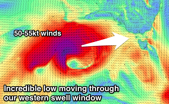
Behind this strong mid-latitude front a very intense and deep low pressure system is forecast to form south-west of WA, bottoming out in central pressure at 954 hPa.
As this low deepens a very impressive fetch of storm-force W/SW winds will be generated in our western swell window from Friday evening, pushing east-northeast up towards the Bight (on top an active sea state from the systems before) while maintaining its strength.
The prolonged fetch of storm-force winds is quite amazing and with this an XXL swell will be generated for South Australia, while we'll see a large long-period W/SW groundswell impacting our coasts from late Monday, peaking overnight and easing Tuesday.
With core wind speeds reaching 50-55kt+ peak periods are due to reach 21-22s, and we should see the groundswell building rapidly right after these fore-runners hit the coast.
Monday morning will see moderate amounts of mid-period W/SW swell as the weakening low moves in and across us through the morning, coming in around a similar size to Sunday afternoon (3ft Surf Coast and 5-6ft Mornington Peninsula).
 The swell should build slowly through the day before the groundswell proper arrives, building rapidly to 6ft+ by dark on the Surf Coast and 10ft on the Mornington Peninsula.
Larger surf is due overnight when the swell peaks, followed by a steady easing trend Tuesday from the 6ft range on the Surf Coast and 8-10ft on the Mornington Peninsula.
Winds through Monday morning look offshore for the Surf Coast with a W/NW breeze, but a W/SW change is due through the day as the remnants of the low push east.
Another strong low forming on the back of the initial system is then due to approach from the south-west, swinging winds back offshore Tuesday from the W/NW, holding all day.
Another large reinforcing groundswell is possible from this system Wednesday afternoon, but more on this in Friday's update.


Comments
Farrrkkk. Leaving 1ft slop and heading to the 1ft slop on the Gold Coast this Saturday. Going to miss all the fun here next week.
The models are still grappling with the structure of the low as expected (not as perfect as yesterday's image) but with storm-force winds projecting east through Vicco's swell window like below, everything it still on track. The peak looks to be Monday afternoon/evening now.
theres almost a vertical line. on the left side super strong southerlies and just ont the other side light variable winds? I'm a complete weather kook but I did no systems worked like that?
"With core wind speeds reaching 50-55kt+ peak periods are due to reach 21-22s, and we should see the groundswell building rapidly right after these fore-runners hit the coast."
Severe energy swell interval !