Fun waves to end the week, back to winter next week
Victoria Forecast by Craig Brokensha (issued Wednesday 30th August)
Best Days: Boht coasts tomorrow morning, east of Melbourne Friday and swell magnets Saturday and Sunday morning, Surf Coast Sunday afternoon
Recap
Great waves across the Surf Coast reefs all day yesterday with waves in the 3ft range, similar if not a touch smaller this morning with good conditions but an onshore change has now moved through.
This change is linked to a broad polar front pushing up and across Tassie, with some new S/SW swell due to 3-4ft across the Surf Coast this afternoon and 5-6ft on the Mornington Peninsula.
This week and weekend (Aug 31 – Sep 3)
The S/SW swell expected off the polar front this afternoon should hold into tomorrow morning but easing thorough the day. The Surf Coast should see easing waves from 3ft to occasionally 4ft early, and surf in the 4-6ft range on the Mornington Peninsula.
A light variable wind should create favourable conditions across both coasts before tending more E/SE into the afternoon.
Into Friday the exposed beaches will be best as the swell eases from 2ft+ on the Surf Coast and 3-4ft on the Mornington Peninsula with a moderate to fresh N/NE breeze.
As touched on Monday, there's no new swell due Saturday, with the Surf Coast expected to become tiny while the Mornington Peninsula should see 2ft to occasionally 3ft waves through Saturday and Sunday mornings. Conditions will be good for the beaches though with a gusty N'ly breeze Saturday and Sunday morning, tending NW-W/NW into Sunday afternoon with an approaching front.
There should be some new inconsistent W/SW groundswell Sunday afternoon, generated by a strong but distant polar frontal progression that's currently projecting from the Heard Island region towards WA.
This will produce a fun but very inconsistent W/SW groundswell for Sunday, building to 3ft at swell magnets in the afternoon on the Surf Coast and 4-5ft+ on the Mornington Peninsula.
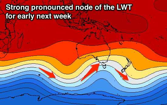
 Now moving into next week, we're due to see one of the strongest cold-outbreaks we've seen this year occurring across the south-east of the country as a strong and pronounced node of the Long Wave Trough moves across us early next week.
This will project a flurry of strong frontal activity up and into us from Monday through Wednesday before the nodes shifts more east and we see follow up polar frontal activity in our southern swell window.
The models are still changing around a little with the timing and alignment of each frontal system, but it looks like the first will approach from the west generating a building W/SW groundswell later Monday, peaking Tuesday morning. We'll then see a secondary polar front project up from the south-southwest, generating a secondary swell but the timing of this is unknown as yet, with the latest updates going with a cut-off.
Winds are still a little undecided as well, so check back when we'll have a greater idea on the setup across the state.


Comments
cold enough for spring snow :)
Yep, lots of it as well!