Easing surf tomorrow, good swell later Friday, easing Saturday
Victoria Forecast by Craig Brokensha (issued Wednesday 1st March)
Best Days: East of Melbourne tomorrow morning and Saturday mid-morning through early afternoon
Recap
Small fun waves across both coasts yesterday morning as a new SW swell started to build, from 2ft on the Surf Coast through the morning and 3-4ft on the Mornington Peninsula.
The surf was strongest into the afternoon and evening with 5-6ft sets reported east of Melbourne with weak sea breezes and generally clean conditions.
This morning the swell was easing with more variable winds on both coasts, easing from 2ft on the Surf Coast (2-3ft 13th Beach) and 3-5ft on the Mornington Peninsula.
This week and weekend (Mar 1 – 5)
Looking at tomorrow and our current swell is expected to continue easing leaving small to tiny waves on the Surf Coast and waves in the 3ft range on the Mornington Peninsula.
Conditions are looking OK at most spots though with a variable wind during the morning ahead of afternoon sea breezes.
 Into Friday the S/SW groundswell event has been upgraded, with the polar low responsible due to produce a good gale to severe-gale W/SW fetch through our southern swell window this afternoon through tomorrow.
The swell is due to kick strongly into the afternoon, reaching an easy 3ft on the Surf Coast by dark and 4-5ft+ on the Mornington Peninsula, peaking overnight and easing from a similar size Saturday morning.
Unfortunately conditions Friday will be poor with a moderate to fresh S/SE wind tomorrow morning, tending lighter through the day before increasing from the E/SE mid-late afternoon.
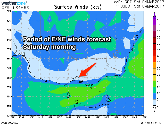
Saturday looks OK with a fresh E/SE breeze at dawn, tending lighter E/NE through the morning ahead of mid-afternoon E/SE breezes.
Due to the delayed onset of the E/SE winds, SE windswell is expected to be minimal on the Surf Coast until early next week when we do see the winds pick up and establish themselves through Bass Strait.
But coming back to Sunday and there isn't due to be much size left, along with SE winds.
Next week onwards (Mar 6 onwards)
As talked about last update, a stronger and broader surface trough deepening off the East Coast is expected to see persistent and strong E/SE winds developing through Bass Strait early next week, generating poor levels of SE windswell along with blocking our main swell windows.
With this we'll see small background SW swell energy through next week. More on this Friday though.

