Sunday fun at swell magnets, similar Monday
Victoria Forecast by Craig Brokensha (issued Friday 20th January)
Sign up to Swellnet’s newsletter and receive the Victorian Forecaster Notes and latest news sent directly to your inbox. Upon signup you'll also enter the draw to win a surf trip to P-Pass for you and a mate (there's only 1 week left to go). It doesn’t get much easier so click HERE to sign up now.
Best Days: Sunday morning east of Melbourne, swell magnets both coasts Monday morning, Surf Coast early Wednesday
Recap
Some good size across both coasts yesterday but with onshore winds. These winds eased off through the morning though, creating fun conditions before fresher sea breezes kicked in.
This morning a small window of clean conditions were seen across all locations with easing 2ft waves on the Surf Coast and 3ft sets on the Mornington Peninsula, but an onshore change has since moved through, creating poor conditions.
This weekend (Jan 21 - 22)
There's been a slight upgrade in the size expected across the coast tomorrow morning, but it will just consistent of weak and easing SW windswell.
This will be from the change pushing through at the moment, with a junky 2ft of windswell expected to ease on the Surf Coast, 3ft on the Mornington Peninsula. Conditions will be average with an easing SW breeze, although the Torquay region may see early variable winds. It's not worth chasing at all though.
Sunday is still looking good on the beaches with a small mix of new W'ly and W/SW swells.
The Surf Coast isn't expected to offer any real size with infrequent 1ft to maybe 2ft max sets at magnets, while the Mornington Peninsula is only due to come in around 2-3ft.
Conditions will be great across exposed breaks with an E/NE tending NE wind ahead of sea breezes.
Next week onwards (Jan 23 onwards)
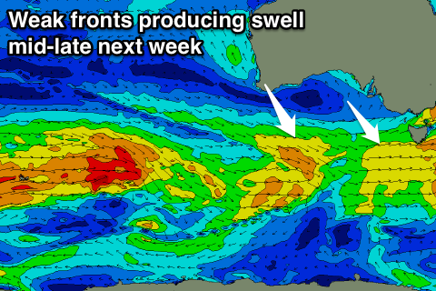
Small amounts of W/SW swell should continue early next week from less than favourably aligned and weak mid-latitude frontal activity to the south-west and south of WA.
Inconsistent 1-2ft surf should continue on the Surf Coast Monday with 3ft+ sets on the Mornington Peninsula and conditions will be good on both coasts with local offshores, tending variable into the afternoon.
 Through Tuesday a mix of slightly bigger long-range W/SW swell and close-range W/SW swell will build, persisting through the rest of the week.
The long-range energy is currently being generated by a relatively weak polar front south-west of WA, while the short-range energy will be produced by a strengthening fetch of broad W/SW winds moving towards us Monday and through Tuesday.
Behind this another slightly stronger front should move in, producing a touch more swell for Thursday/Friday.
Size wise, the Surf Coast is only due to be around 2ft Tuesday morning, and 3-4ft+ on the Mornington Peninsula, increasing slightly later in the day.
Wednesday should see a touch more size but only to 2ft to near 3ft on the Surf Coast and 4-5ft on the Mornington Peninsula, slightly stronger Thursday afternoon and early Friday.
Winds will be an issue, offshore Tuesday morning for the Surf Coast, but swinging onshore, and then SW Wednesday (likely W'ly early on the Surf Coast). Thursday looks onshore from the S/SE, persisting Friday, but we'll review this Monday. Have a great weekend!


Comments
Coupla little sliders at Lorne this arvo.