Great Friday, plenty of swell for the weekend but onshore
Victoria Forecast by Craig Brokensha (issued Wednesday 23rd December)
Best Days: Thursday morning small waves east of Melbourne, Friday both coasts, Tuesday morning east of Melbourne
Recap
Average onshore waves across both coasts yesterday to a choppy 2ft on the Surf Coast and a more workable but still onshore 3-5ft on the Mornington Peninsula.
Today the swell was smaller and improving across both coasts as light onshore winds eased, with 1-2ft leftovers on the Surf Coast and better 3ft sets on the Mornington Peninsula.
This week and next (Dec 24 - Jan 1)
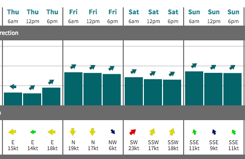
Cleaner conditions are due into tomorrow across the Mornington Peninsula with a NE offshore but the swell will be minimal with inconsistent 2ft+ sets.
A late afternoon increase in new long-range W/SW groundswell should see sets push up to 3-4ft, but E/SE breezes are likely mid-afternoon.
The long-range W/SW groundswell is due to peak Friday, and it's currently building across the South West of WA with large clean pumping surf on offer.
 While inconsistent we should still see strong 3ft to occasionally 4ft sets across swell magnets on the Surf Coast through the morning, with 6ft+ sets on the Mornington Peninsula (8ft bombs at swell magnets).
Conditions should be clean with a fresh and hot N'ly wind wind (tending N/NW at times on the Surf Coast and N/NE on the Mornington Peninsula).
A slight drop in size is expected through Saturday with the longevity helped by the stationary nature of the polar low generating the swell.
Unfortunately a cool onshore SW change is due around dawn Saturday creating poor conditions, persisting into Sunday from the S/SE.
This will spoil a good new mix of W/SW and SW groundswell from a front spawning off the low, pushing east through the Bight and then deepening into another polar low to our south-west Friday and early Saturday.
This should see the surf kick back to 3-4ft on the Surf Coast and 6ft to possibly 8ft on the Mornington Peninsula but with those average S/SE winds.
Unfortunately as the swells ease Monday, SE winds are due to continue, swinging more E'ly through Tuesday as the size continues to drop. The Mornington Peninsula will be the pick with easing 3-4ft+ sets.
Longer term some fun W/SW groundswell energy is due into the middle to end of next week from some strong frontal activity pushing up towards WA through the weekend and early next week.
Better winds are expected for these pulses as a slow moving high sets off the East Coast, but we'll have another look at this Friday.

