Clean easing surf over the weekend, average until Wednesday next week
Victoria Forecast by Craig Brokensha (issued Friday 18th December)
Best Days: Monday both coasts, Tuesday and Wednesday east of Melbourne
Recap
Cleaner conditions yesterday morning but with no real size across the Surf Coast and inconsistent 2ft+ waves on the Mornington Peninsula.
Today a better long-range W/SW groundswell pulse has filled in as expected with clean 2ft sets on the Surf Coast and 4ft waves on the Mornington Peninsula.
This weekend and next week (Dec 19 - 25)
Today's inconsistent W/SW groundswell is due to ease back through tomorrow from a similar 2ft on the Surf Coast and the 3-4ft range on the Mornington Peninsula under light local offshore winds across both coasts.
Conditions should remain favourable until midday, and even early afternoon, with a freshening inland NW breeze possibly suppressing the sea breeze. Keep an eye on the cams and local observations for decent conditions most of the day!
Sunday will be clean again with a fresh morning N'ly wind but the swell will be tiny on the Surf Coast and only around 3ft+ or so on the Mornington Peninsula. A strong SW change is due late morning/midday so get in early for the best of it.
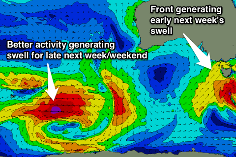
 Early next week's swell has fallen apart a little more since Wednesday with an intense mid-latitude low forming off the south-west tip of WA today being too far north to generate any decent W'ly swell for us.
Instead we're relying on the secondary intensification as it tracks east-southeast and deepens directly south-west of us during Sunday.
With this a short-lived burst of strong to gale-force SW winds will be aimed through our swell window as the low continues tracking south-east.
This isn't favourable at all, and now only a small kick in mid-period SW swell is due through Monday, building to a messy 2-3ft on the Surf Coast with fresh and gusty but easing SW winds, and 5-6ft on the Mornington Peninsula.
The swell should ease through Tuesday from a similar size but with onshore SE winds.
Improving conditions are expected across the Mornington Peninsula into Wednesday and further Thursday with easing 3-4ft sets on the former, and inconsistent 2-3ft sets on the later.
Longer term a series of strong polar fronts firing up south-west of WA under the influence of the Long Wave Trough should produce some better W/SW groundswell for Christmas Day and the following weekend, but more on this Monday. Have a great weekend!


Comments
A sea fog has developed from the Bellarine Peninsula all the way to the SA border this afternoon as a result of moist air with a dew point higher than that of the ocean.
Current ocean temps off Point Nepean are registering 18.6, but the dew point is around 16 at Aireys, so there could be some localised upwelling west of Melbourne to the border? (sea fog isn't present across the Mornington Peninsula).
Has anyone who surfed this morning from the Surf Coast further west noticed cooler ocean temps?
Looks like it was around yesterday as well on the West Coast..
surfed Bells this morning, about an hour too late, was cheering Mick! :-(
Water seemed about the same, was thinking I really need a short arm wetty!!
Hit morn pen pretty hard. Couldnt even see futher than 100meters here and there. Only like portsea sorra blairgowrie. Rosebud was still hot and sunny
Nice guys, yeah saw it push into the MP mid-afternoon.
So the dew point has to be lower than sea temp? It seemed asthough it was coming from the east due to the south east. So what does aireys inlet have to do with it?
No the dew point has to be the same or higher than the sea temp. I used Aireys to get the coastal dew point which was around 16. But if ocean temps were 18 as they are showing at Point Lonsdale the dog shouldn't have formed...
Weird wind activity last night in blairgowrie. Standard SE seabreeze, began to ease around 630. Around 7 a westerly kicked up complete with incoming wind line. Lasted about 5 mins then went completly still. Then SE kicked back in. Nature just doing natures thing?
Was out with grom this morning around the low tide, clear but W-SW (?) wind change came in earlier and stronger compared to what I was expecting, TQ area. Water temps were noticeably warm in town. Cloud/fog developed later. Day was a lot cooler than what we were expecting, thanks seafog!
One cool thing was the beachie we were on was largely ripless until the wind changed into that W vector, then there was an instant rip to deal with on the little righthanders.
Craig mate,
Any chance of some sea fog later on today like yesterday developing I no it's very foggy at the moment what about for example at midday today any chance
Water at discovery went from warm , to 4.3 steamer and hoods overnight , almost winter water temps, at least on the first day i got to sit in the sun and thawe out, while in town was cold overcast all day go figure ,east wind upwellings hate them ....
Hi Ben. What is the fog forecast (or as I like to call it - the 'fogcast') looking like for Boxing Day? Would love to try out my new board and impress the girls on the beach.
PS. Feel free to use the term 'fogcast'. Just make sure you give me credit for it.