Fun Sunday east of Melbourne, Surf Coast from Tuesday
Victoria Forecast by Craig Brokensha (issued Friday 24th October)
Best Days: Early tomorrow on the Surf Coast for keen surfers, east of Melbourne Sunday morning, Surf Coast from Tuesday
Recap
Yesterday started off average with a small swell and onshore winds, but a new SW groundswell built through the afternoon as winds eased, providing better conditions across the Surf Coast for an mid-afternoon paddle.
Today was the tricky one, and it looks to have played out as expected, with early onshore E/SE winds easing quickly and swinging light N'ly cleaning up a mix of peaky swells on the Surf Coast to 2-3ft while the Mornington Peninsula offered peaky 3-5ft sets.
Conditions should remain good into the early-mid afternoon ahead of a SW change late afternoon.
This weekend (Oct 25 - 26)
Tomorrow is looking a touch better across the Surf Coast early with a light W/NW'ly due before a weak S'ly develops late morning. The swell will be small and easing from 2ft though, while the Mornington Peninsula will be lumpy and in the 3-4ft range.
A new long-range and inconsistent SW groundswell due later tomorrow, should peak Sunday morning but only offer infrequent 1-2ft sets on the Surf Coast, with 3-4ft waves on the Mornington Peninsula.
Conditions will be good across the Mornington Peninsula with a light NE'ly before E/SE sea breezes kick in.
Next Monday onwards (Oct 27 onwards)
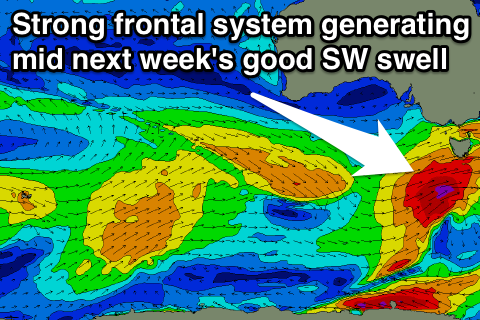
Monday morning will be a day to miss with it starting out tiny under fresh W/NW winds. A new acute W/SW swell is due into the late afternoon though, generated by a quick burst of W/SW gales in our western swell window overnight Sunday and early Monday.
This will unfortunately come with a fresh W/SW change during the afternoon though, with Tuesday providing better waves as winds veer back to the W/NW and a stronger secondary pulse of W/SW groundswell fills in.
 This secondary pulse of swell will be produced by a secondary stronger cold front pushing in quickly behind the initial system, aiming a fetch of W/SW gales through our swell window Monday afternoon/evening and then better SW gales Tuesday morning.
A good W/SW tending SW groundswell should fill in, building through Tuesday afternoon and peaking Wednesday morning.
Size wise the Surf Coast should build from the 3ft range Tuesday morning with 4ft sets into the afternoon, before peaking Wednesday morning to 3-5ft. The Mornington Peninsula should see 6ft waves, building towards the 8ft range Tuesday afternoon and peaking at 8ft+ Wednesday morning.
Winds should swing from a fresh and gusty NW'ly around to the W/SW during Tuesday and then Wednesday should offer lighter but still fresh at times W/NW tending W/SW winds.
From Wednesday morning onwards wave heights will slowly dip away, but this will be slowed by some smaller reinforcing SW swells into Thursday afternoon and Friday. Winds should become more favourable and from the N/NW Thursday morning and then offshore from the N/NE on the Mornington Peninsula Friday, but we'll go over this again Monday. Have a great weekend!

