Waves right around the coast this weekend
Victorian Surf Forecast by Ben Matson (issued Friday 23rd May)
Best Days: Sat: good winds for the Surf Coast with a fun S/SW swell. Sun: good winds for everywhere with an easing S/SW swell. Mon: keep an eye out for a sneaky S/SW swell early morning.
Recap: Small residual, easing swells Thurs with good winds. Freshening NW tending W’ly winds today with a slowly building S/SW swell.
This week (May 22-23)
*sorry - super short today as I’m low on time. Craig is back next week*
This weekend (May 24-25)
Great weekend of waves on the whole. A peak in S/SW swell is expected Saturday morning, with mainly W/NW winds slowly easing and swinging N’ly throughout the day, which will favour the Surf Coast (sets of about 3ft).
Locations east of Melbourne will probably suffer on Saturday due to the current/overnight W’ly breeze, so give it a miss here and aim for Sunday - slowly easing surf and a N/NE breeze (tending NW late) that’ll do good things across the open beaches. There'll still be some small clean waves west of Melbourne on Sunday but really only at the exposed beachbreaks.
Next week (May 26-30)
We’ve still got a complex forecast period ahead for next week. First things first - the possible large S/SW swell for Wed/Thurs has essentially been wiped off the charts - instead we’re looking at a steady progression of vigorous (i.e. windy) fronts across the mid-latitudes next week, roughly between the northern Bight and Tasmania. This means we’re going to see a lot of west in the swell direction, so despite winds favouring mainly the Surf Coast, surf size will be heavily attenuated here.
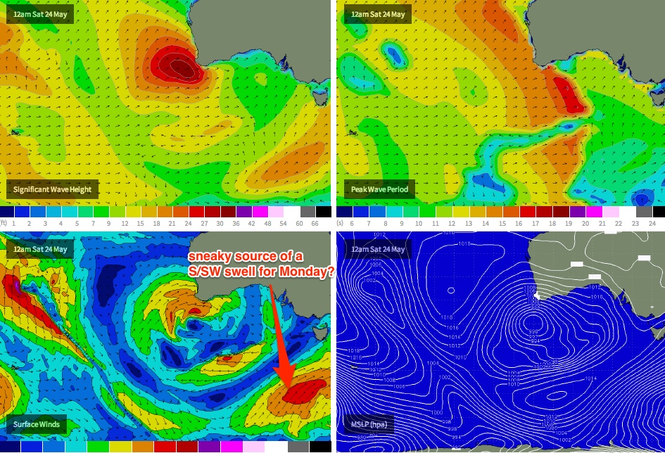
Just keep an eye out for a possible sneaky S/SW swell on Monday generated by the tail end in this most recent Southern Ocean frontal passage, on Saturday (see chart below). The wave models are not picking it up well, mainly because the fetch is expected to develop right on the eastern periphery of our swell window (i.e. mainly behind the swell shadow Tasmania) but I wouldn’t be surprised if we saw some swell energy swing up either side of King Island (yes, there’s an unusual swell window between NW Tas and King Island that can do weird and wonderful things with swells across the central Victorian coast!).
This pulse - if it arrives - has an ETA overnight on Sunday so it’ll be worth monitoring the Sorell buoy in the early hours of Monday morning for signs of life, as light N’ly winds should keep conditions clean at most spots. I’m going to go out on a limb and predict fun 2-3ft waves on the Surf Coast for the Monday dawn patrol (up from the current model prediction of 1ft+), with clean 4ft surf east of Melbourne.
After Monday, we’re looking at mainly small residual energy through Tuesday and Wednesday ahead of a period of gusty, building W’ly swells through Thursday and Friday - we’ll probably see 3-4ft sets in Torquay but you’ll have to work around a few small windows of opportunity between each front. Expect large, blown-out surf east of Melbourne with the only rideable options inside Western Port.
Longer term (May 31 onwards)
More frontal activity expected into next weekend and the following week. All fairly standard for this time of year which is a promising sign. More from Craig on Monday!


