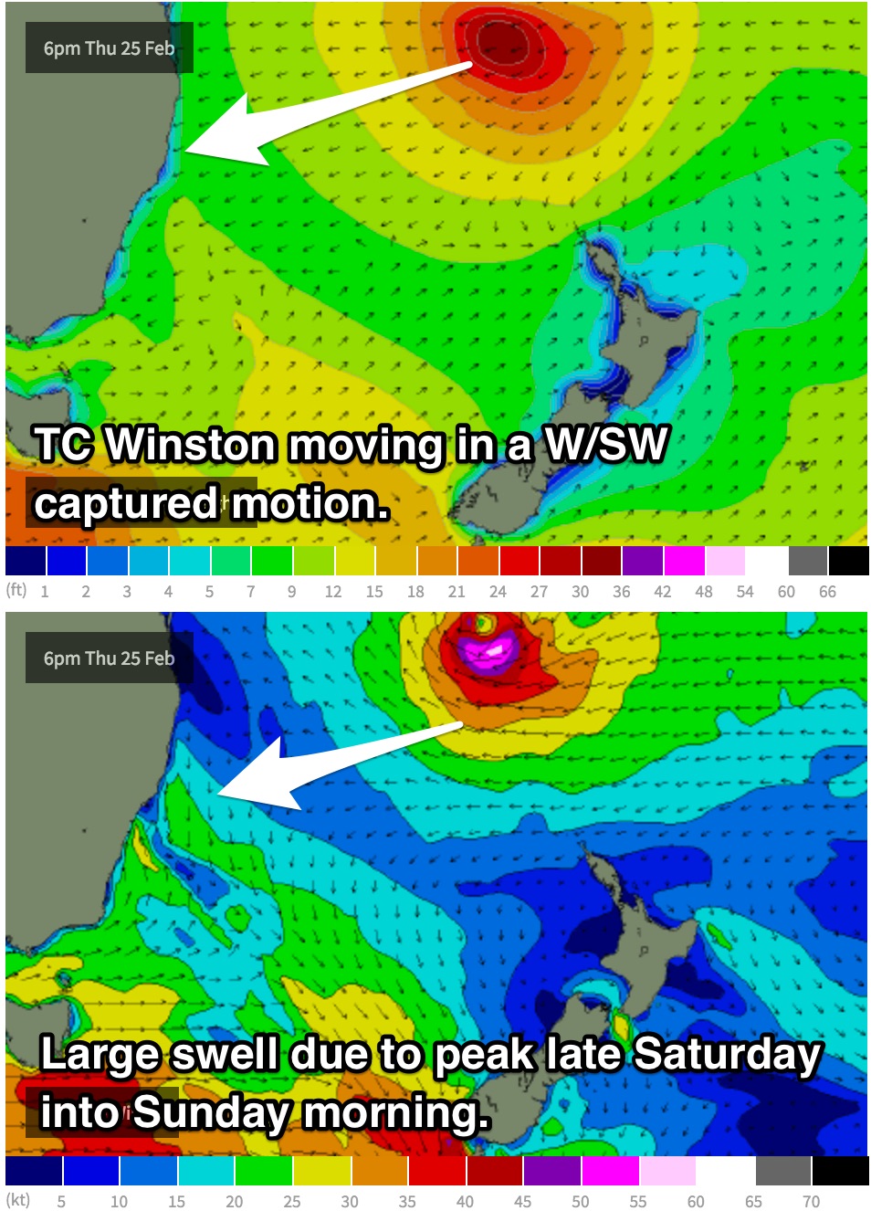
Large and powerful E/NE swell due to peak on the weekend
Sydney, Hunter and Illawarra Surf Forecast by Guy Dixon (issued Monday 22nd February)
Best Days: Early each morning this week, then limited to protected southern corners/points/reefs on Friday and Saturday morning.
Recap:
Saturday saw fairly lacklustre conditions with around 2-3ft of surf, but wind affected under a gusty southerly breeze with only the southern corners of the open beaches offering anything worth while.
Southerly groundswell generated by a strong but poorly aligned fetch further south front graced our shores on Sunday, especially at south facing beaches where the surf grew to around 3ft, with the occasional bigger bombs. Light offshore breezes allowed for clean conditions early, becoming seabreezey later, but still generally workable as winds were fairly light.
A lot of the energy has faded today, with residual easterly swell becoming the most dominant source of energy once again. Open beaches are doing the best with occasional sets in the 2ft range with only a light seabreeze adding a small amount of bump into the mix.
This week (Tuesday 23rd - Friday 26th):
We are expecting hints of the next pulse of east/northeasterly groundswell to begin filling in across the open beaches late this afternoon, although likely lacking much size. A lot of the energy is expected to build throughout Tuesday, with open beaches increasing to the 3-4ft range by the afternoon.
The early morning holds the best chances of a clean wave under a light north/northwesterly breeze, although it wont take long for a north/northeasterly seabreeze to have an impact on the quality.
Periods are expected to gradually drop off throughout Wednesday, however the surf should still hold in the 3-4ft range throughout the morning, before easing during the late afternoon.
Protected northern corners will be the best bet, even from early morning as breezes look to prevail from the north/northwest, tending northerly and eventually northeasterly as the day wears on.
This pulse of swell is largely as a result of an intensification of Severe Tropical Cyclone Winston and the associated feeder ridge located to the south late last week. Sets are likely to be inconsistent to start off with due to the long range nature of this swell, improving marginally into Wednesday.
We are due to see another pulse on Thursday morning maintaining options in the 3-4ft range, with the possibility of a touch more size on dark. Meanwhile, a local northeasterly fetch also looks to develop off the coast throughout Wednesday before peaking on Thursday with short range energy in the 3ft range, larger on the South Coast.
Thursday is looking slightly more favourable for a wave early, but only just. We may see a brief window of northwesterly breezes early, increasing from the northeast soon after preceding a southerly change.
Winston is due to begin drifting southward from around Tuesday out from behind the swell shadow of New Caledonia which bodes well for the coast of NSW. Things look to become interesting late in the week as long range energy continues to build.
Friday should see open beaches build to the 4-5ft by the late afternoon, with points and reefs offering the best options under a gusty southerly breeze.
This weekend (Saturday 27th - Sunday 28th):
 Throughout Wednesday and Thursday, models indicate Winston to move in a west/southwesterly direction towards the east coast coast of Australia, moving in a captured motion with fetches of 40-50kts.
It’s not often that a system like this move in a captured motion with such alignment to the NSW coast, in fact there is some very interesting commentary in the comments section of southeastern QLD/northern NSW forecast notes which discusses the track of TC Sose (Summer of 2000/01) which moved in a comparable motion, although not moving as close to the east coast as this occasion.
Open beaches have the potential to build to 6ft+ on Saturday, with the chance of sets around 6-8ft on dark, fading from a similar size on Sunday. Swell magnets that are known to amplify these long period east/northeast groundswells along with offshore reefs will be bigger again at the swells peak and likely see 10ft bombs.
Again, this swell is easily favouring the points and reefs in the early morning as breezes continue from the south, however as the day wears on, breezes look to tend southeasterly, leading to bumpy conditions.
Now going out on a limb and calling this type of swell based off one model isn’t the wisest of moves, but the alternative scenario is similar, instead not pushing in quite as close to the coast. Nevertheless, the latter synoptic setup would still be conducive to solid 6ft surf across the open beaches.
It is worth mentioning that this swell is likely to be very powerful with solid wash through sets. Easterly swells of this magnitude are a rarity along these parts of the coast so it’ll be only for the experienced surfers.
Unfortunately, Sunday looks to be dominated by a light onshore airflow, with only the early morning offering a period of light/variable-offshore breezes.
Next week (Monday 29th onward):
Looking long term, the situation looks too good to be true. Call me a pessimist, but this swell surely cant give another round of swell can it? Looks like it may.
After undergoing extra-tropical transition, models suggest this system could stall over the Tasman sea as a small ridge sets up to the south. A resultant east/southeasterly swell is on the cards for midway through next week, but this scenario has a pretty good chance of changing in the coming days.


Comments
From my (rusty) memory banks, reminds me of the Cyclone Wati setup in 2006. Any charts of this handy that can confirm?
Similar, although Wati moved north of New Cal
Just realised the Aus Open comp is on at Manly this weekend... would they dare hold it at Bower, Winki or the Bombie?
No
The banks are pretty good at Manly for a big swell
The question is not if the banks at N Steyne can handle it - its whether the competitors can!
Wouldn't believe it but I've got a 2 days festival right over the swell peak :/ Man would love to suss some out of the way zones...
I might have the same engagement, Craig - although when Gaz is in the house, no bridge is too far.
Which mask will you be wearing?
I'll come give you a tap on the shoulder, just remember what happens on tour stays on tour, Gary won't kiss and tell.
Make sure you help him suss out those "out of the way zones" G, but just be gentle...
Are there any sheltered spots from the S wind on the eastern beaches near bronte?
The current projected charts have my eyes lit up with the retrograde back to the sw.Any thoughts of July 2001?
I was down kiama way during that 2001 swell. Just so happens I have a party down there this weekend. History repeating...
I'd been thinking similar, though not so much for the retrograde but more for the positioning above NZ's North Island.
Here're the charts from 2001.
Awesome Stu! This could be a bucket list swell.Now I'm thinking are the winds going to be my friend.