Small average period ahead; next week looks much better
Sydney, Hunter and Illawarra Surf Forecast by Ben Matson (issued Monday 9th March)
Best Days: No great days due to mainly small swells and/or poor winds.
Recap: Jeez, Saturday was incredible, eh? That second south swell punched much higher than expected. Exposed south facing beaches in Sydney pulled in 6-8ft sets (bigger in the Hunter) but a few of the region’s swell magnets (i.e. offshore bombies) saw upwards of 10-12ft+ at times. The swell sharply dropped through Sunday (3-4ft+ south facing beaches, smaller elsewhere) and has eased further overnight with most beaches seeing 2ft to almost 3ft waves.
This week (Mar 10 - 13)
Not much surf is expected for the next few days.
Since the weekend’s low pressure system moved outside our swell window, there’s been a general lack of synoptic activity favouring New South Wales, so we’re looking at minor energy for the next three days. A broad ridge of high pressure across the Tasman Sea will deflect approaching frontal systems to the south-east, meaning very little activity from the southern quadrant.
Today’s SE energy will ease through Tuesday, so exposed south facing beaches should have a few small waves on offer for the early session but don’t expect much throughout the afternoon, or Wednesday, or Thursday for that matter.
Light winds - mainly E/SE on Tuesday - will tend NE on Wednesday and freshen ahead of a shallow southerly change due sometime Thursday. A more established SE airstream will develop behind this change (into Friday) and this will build a short range windswell across the region to finish the week (3ft+ south facing beaches, smaller elsewhere), but conditions are expected to be poor at exposed beaches under an onshore airstream.
So all in all, don’t get too excited about this week’s surf prospects.
This weekend (Mar 14 - 15)
Friday’s short range south swell should hold through into Saturday, in fact the models are suggesting a ridge across the southern Tasman Sea could strength later Friday, giving us a brief pulse early Saturday morning.
However for the most part this swell source will weaken from Saturday onwards, so a general easing trend is expected through Saturday and into Sunday. Local winds will probably remain from the SE but should ease back from Friday so conditions will slowly improve.
On Sunday, the fading leftover SE swell will mix in with a small E/NE swell courtesy of a building trade flow across the Northern Tasman Sea during the week. No great size is expected from this source however if we see light winds the open beaches should provide a few peaky options. I’ll re-evaluate this in more detail on Wednesday.
Next week (Mar 17 onwards)
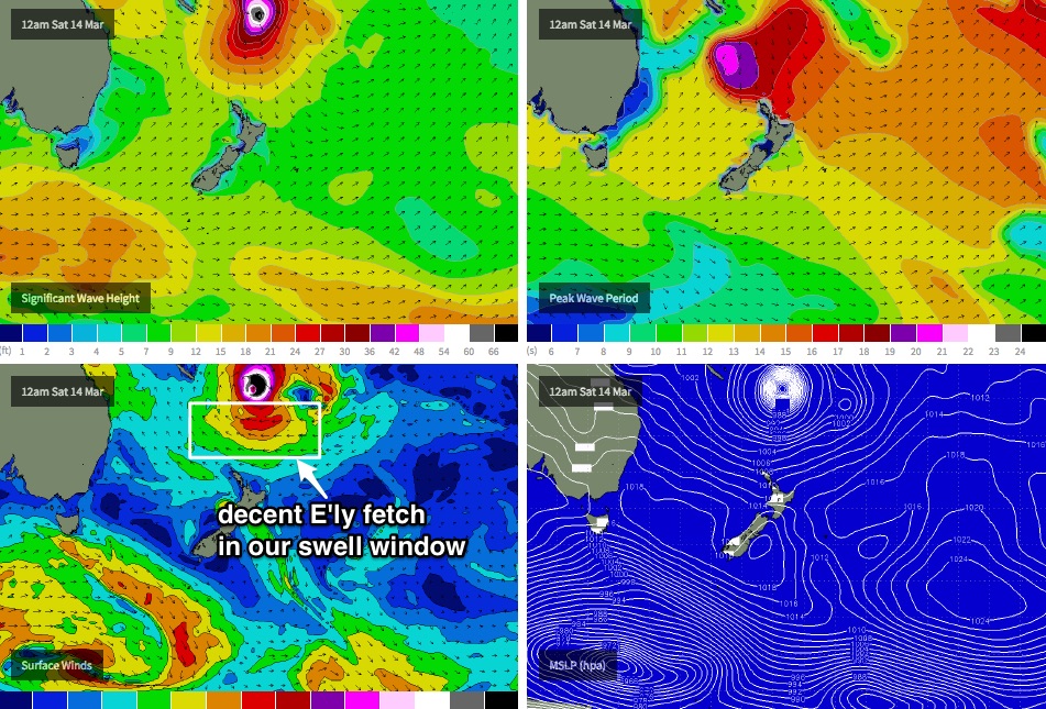
Tropical Cyclones, eh? Amidst much of the hyperbole in recent days, this system really doesn’t look especially favourable for southern NSW, for a couple of reasons.
Firstly, the strongest intensification phase of the cyclone will probably occur inside the swell shadow of the South Pacific islands (i.e. Vanuatu, New Caledonia et al), and during that time the strongest flank of the cyclone will be its eastern side (ie W'ly thru' N'ly winds, aimed to the south-east).
We’re now getting a firmer grip on its future track too, and this is likely to be to the south-east, post haste: also not a good development (as it’ll be perpendicular to the great circle paths).
However if you assess the supporting ridge to the south in isolation - i.e. ignore the cyclone itself and just look at the broader trade flow - there is a reasonable E'ly fetch developing between Friday and Saturday. This should be worthy of a steady increase in stronger trade swell (2-3ft) from Monday afternoon, ahead of a fairly solid E/NE swell peaking sometime later Tuesday or early Wednesday (4-5ft sets at NE facing beaches).
Right now I think our model is slightly overcooking the data, probably due to the inclusion of NE groundswell from the core of the cyclone, which I am discounting as I don’t think the environment is sufficiently well set up to allow this to contribute significant energy from such a distant source.
It can't be completely ruled out right now, however gut feeling is that it won't favour our region very well.
Furthermore, if one were to consider the overall trend of the models in recent days, its likely that we will see a further small downgrade from what I’ve estimated above (Wednesday will surely offer much greater insight to this). But for now: 4-5ft Tuesday afternoon and early Wednesday is a reasonable ballpark. Expect long breaks between sets.
Otherwise, we’ve got another Tropical Cyclone lining up in the long term models, this time in the Northern Coral Sea. It’s (once again) way to early to have any confidence on swell potential from this source, but nevertheless it’ll keep our eyes firmly focused to the tropical regions for the next week and a half.
Looking further afield, and there’s nothing out of the ordinary expected form the South Ocean in the long term - just a few moderate frontal progressions. This lack of distraction is a good thing.. as it’ll help us concentrate on the tropics for the upcoming forecast period.


