Fun surf from Wednesday, larger into early next week
Southern Tasmanian forecast by Craig Brokensha (issued Monday March 31st)
Best Days: Wednesday, Thursday morning, Saturday, Sunday onwards
Features of the Forecast (tl;dr)
- Moderate + sized SW groundswell tomorrow with mod-fresh S/SE winds
- Easing swell Wed with variable N/NW winds ahead of weak sea breezes
- Small Thu with W/NW tending strong SW winds into the PM
- Fun SW swell Sat and Sun AM with strengthening W/NW winds Sat
- Building W/SW swell Sun ahead of stronger SW energy early next week
Recap
Saturday was clean and small with 1-2ft of swell before sea breezes kicked in. A strong pulse of new swell filled in yesterday but conditions were onshore and poor thanks to a trough moving through.
Today there was a window of clean conditions again and 2ft surf before winds again shifted onshore through the morning.
This week and weekend (Apr 1 - 6)
Later today but more so tomorrow our stronger increase in SW groundswell is due, generated over the weekend by a great polar fetch of W-W/NW gale to severe-galeforce winds.

This should come in at a strong 4ft across Clifton tomorrow, easing back from 3ft on Wednesday but winds still look dicey. Moderate to fresh S/SE winds will persist tomorrow, with a variable N/NW offshore due Wednesday ahead of relatively weak sea breezes. Thursday will then see W/NW tending strong SW winds as a trough moves through.
No major swell is due from this trough on Friday, with a tiny W/SW swell for the afternoon being generated too far north of us over the coming days.
A better aligned SW swell is due into Saturday though, produced by a polar frontal system that will pass through our swell window to the south-west of Western Australia tomorrow evening and Wednesday.
This should come in at a fun, inconsistent 2ft under strengthening W/NW winds.

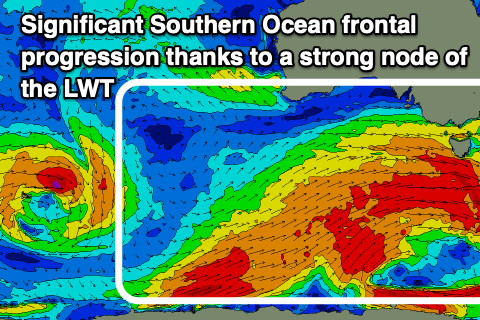
Now, these strengthening winds will be linked to significant, developing Southern Ocean frontal progression across us through the weekend and early next week, under the influence of strong node of the Long Wave Trough.
We’re set to see back to back broad, elongated frontal systems moving across us from Sunday through early next week, generating building levels of W/SW swell initially, then more SW into Monday/Tuesday.
Size wise the swell looks to be moderate to possibly large but we’ll take a closer look at this and the local winds on Wednesday.

