Plenty of swell this period but with poor winds from the weekend
Southern Tasmanian forecast by Craig Brokensha (issued Wednesday March 26th)
Best Days: Today, tomorrow, Friday, Wednesday
Features of the Forecast (tl;dr)
- Easing mix of swells tomorrow with W/NW winds ahead of sea breezes, stronger later
- Small reinforcing swell Fri with variable winds
- Morning N/NW winds Sat with tiny amounts of swell, strengthening from the S from later AM
- Moderate sized mid-period SW swell Sun with gusty S/SE winds
- Junky S windswell Mon with strong S/SE winds
- Moderate + sized SW groundswell Tue mixed in with easing S windswell
- Gusty S/SW winds Tue, tending SW later
- Easing surf Wed with N/NW winds ahead of a late S change
Recap
Monday afternoon’s strong increase in S/SE groundswell backed off from the 2ft+ range yesterday morning under offshore winds, while today we’ve got a building mix of swells in the water that was 2ft early but now looks to be 2-3ft under a great offshore wind.
This week and next (Mar 27 - Apr 4)
Today’s mix of swells are due to ease back through tomorrow from 2ft to occasionally 3ft across Clifton, smaller Friday and to 1-2ft or so.
A light W/NW breeze should create clean conditions tomorrow morning ahead of weak sea breezes, stronger later as a trough slides through.
Friday should again be clean, though a secondary shallow trough is due just on dawn but this will likely just bring variable winds that will remain so for most of the afternoon.
Into the weekend, fading surf is due and a dawn N/NW offshore is due Saturday to give into a strong S’ly change later morning as a stronger trough slides in from the west.

This trough will be attached to a weakening polar frontal system, with a fetch of SW winds due to kick up 2ft to possibly 3ft of swell for Sunday but with lingering, fresh S/SE winds.
The trough will actually merge with a southward tracking inland low across the mainland, forming a low off our east coast through Sunday/Monday.
Strong winds from the southern quadrant will persist into early next week thanks to the low stalling east of us, spoiling a good SW groundswell that’s due later Monday but more so Tuesday.
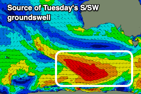
The source of the groundswell will be a great fetch of polar, gale to severe-gale W/NW winds moving along the shelf through the weekend, with Clifton due to come in at 3-4ft but with those gusty S/SW winds.
Wednesday looks nice and offshore for a period with easing levels of swell from the 2-3ft range, but we’ll have a closer look at this on Friday.

