Lots of surf days ahead
Southern Tasmanian forecast by Craig Brokensha (issued Friday March 21st)
Best Days: Every day this period
Features of the Forecast (tl;dr)
- Short-lived but strong pulse of S/SW swell for later today and early tomorrow, easing
- N/NW tending NW then W/NW winds tomorrow ahead of a late SW change
- Moderate sized W/SW groundswell Sun with variable NW winds ahead of variable sea breezes
- Easing swell Mon with N/NW tending S/SE winds then W/SW-SW later
- Flukey small S/SE groundswell for later Mon and Tue with W/NW tending S/SE winds
- Small inconsistent W/SW groundswell Wed with NW tending S/SW winds
Recap
Wednesday’s strong swell eased back through yesterday from the 2ft+ range while the surf bottomed out into this morning. Some new energy has started to show to 2ft with weak onshore winds.
This week and weekend (Mar 22 - 28)
As touched on in Wednesday’s notes, a rapidly deepening low south-west of us yesterday afternoon and evening should produce a decent pulse of short-lived SW-S/SW swell for later today and tomorrow morning.
Sets to 2-3ft are due across Clifton, easing steadily tomorrow and a N/NW breeze will shift more NW through the day and then W/NW ahead of a late SW change.

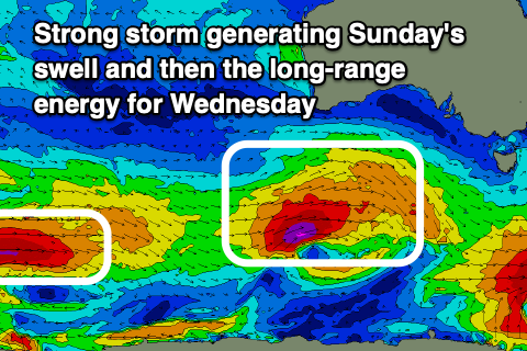
This change will be linked to our next swell generating system moving in, that being a strong low that’s formed south of Western Australia.
A great fetch of gale to near severe-gale W/SW winds will project east towards us today, weakening on approach tomorrow, with a moderate sized W/SW groundswell due to come in around 3ft+ across Clifton Sunday along with variable NW winds ahead of variable sea breezes.
The swell will start easing later Sunday and drop from 2ft into Monday along with light offshore winds again ahead of sea breezes.
Now, moving into later Monday and more so Tuesday, a flukey S/SE groundswell is due, generated by a very significant but small fetch of hurricane force winds off the polar shelf this evening and tomorrow morning.
While flukey we should see 2ft+ sets from this source with more size on the magnets later Monday and into Tuesday, with W/SW-SW winds later Monday and W/NW tending S/SE winds on Tuesday.
Looking at Wednesday and the models are incorrectly combining a long-range swell with the existing energy and over-forecasting the size. The long-range groundswell only looks to provide very infrequent 1-2ft sets with some better swell potential for next weekend. More on this Monday, have a great weekend!

