Two swells inbound, one wrecked by the winds

Southern Tasmanian forecast by Craig Brokensha (issued Wednesday February 5th)
Best Days: Tomorrow morning, early Friday
Features of the Forecast (tl;dr)
- Moderate sized mix of W/SW swells building later today, peaking tomorrow AM, easing
- Moderate N-N/NE winds ahead of strong E/NE sea breezes tomorrow
- N/NW winds early Fri AM ahead of a mid-late PM S/SW change
- Moderate sized W/SW groundswell for later Fri, peaking Sat AM, easing Sun
- Gusty S/SW tending S/SE winds Sat, SE Sun
Recap
There was a window of light winds and easing surf from 1-2ft yesterday morning ahead of a strengthening onshore change, while today we’ve got lingering onshore winds and a tiny, weak swell.
This week and next (Feb 6 - 14)
Later today but more so tomorrow, our mix of W/SW swells are due to fill in and peaky, generated by a strong low that traversed the Southern Ocean, weakening on approach to us before going under one final reintensification yesterday.
This should see Clifton come in around 2ft+ before easing through the day 1ft to occasionally 2ft sets into Friday.
Local winds look good tomorrow and out of the N-N/NE, moderate in strength ahead of increasing E/NE winds into the afternoon.
Friday is then dicey with early variable winds expected to freshen from the S/SW as a trough moves through.
This trough will be related to a strong but weakening polar low moving in from the west, bringing with it a moderate sized W/SW groundswell for Saturday morning.
The low formed south-west of Western Australia yesterday, with it deepening as the remnants of Tropical Cyclone Elvis tracked south-east from Madagascar and was absorbed into the westerly storm track.
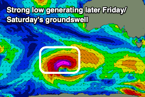
A great fetch of severe-gale to storm-force W/SW winds have been generated, with the low due to weaken today while continuing east.
The swell is expected later Friday but 2ft to occasionally 3ft sets are due across Clifton Saturday morning, easing through the day with smaller 1-2ft waves Sunday.
Unfortunately we’re still expecting gusty S/SW-S/SE winds on Saturday in the wake of Friday's change, creating poor conditions, with Sunday now due to see lingering SE winds. Not ideal at all.
Smaller surf is due into next week as winds slowly improve and persistent, weak polar frontal activity should maintain 1-2ft of background energy.
Later week we may see increasing frontal activity and some new swell, but check back here Friday for more on this.