Varying swell pulses and winds

Southern Tasmanian forecast by Craig Brokensha (issued Monday February 3rd)
Best Days: Early tomorrow, Thursday morning, Friday morning, Sunday morning
Features of the Forecast (tl;dr)
- Easing surf tomorrow with dawn N/NE tending N winds ahead of a mid-late AM S/SE change
- Mod-fresh S/SW winds Wed, easing and then freshening from the S/SE
- Moderate sized mix of W/SW swells building later Wed, peaking Thu AM, easing
- N winds ahead of strong E/NE sea breezes Thu
- N/NW winds Fri AM ahead of a mid-late PM S/SW change
- Moderate sized W/SW groundswell for later Fri, peaking Sat AM, easing Sun
- S/SW winds Sat, E/NE-NE Sun AM ahead of sea breezes
Recap
Saturday was tiny while some new swell arrived into Sunday with variable winds that shifted light S’th. It was inconsistent but to 1-2ft while today our better groundswell has filled in with clean 2ft+ sets ahead of sea breezes.
This week and weekend (Feb 4 - 9)
This morning’s spike in swell will back off into tomorrow but we should still see 1-2ft sets with dawn N/NE tending N winds ahead of a mid-late morning S/SE change.
Go the early.
This change looks to leave moderate to fresh S/SW winds into Wednesday morning, easing through the day ahead of fresh sea breezes.
Later in the day but more so Thursday a mix of inconsistent, long-range W/SW groundswell and bigger, closer-range W/SW swell is due to fill in, produced by a strong low that formed south of South Africa earlier last week but has transitioned across to us, with the remnants currently south of Western Australia.
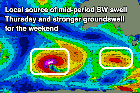
One final intensification of the storm is due as it approaches us tomorrow, with a fun 2ft+ pulse due into Thursday, easing Friday morning to 1-2ft.
Conditions will be clean Thursday morning with a N’ly offshore of strong E/NE sea breezes, with an early N/NW offshore ahead of a mid-morning S/SW change.
This next change will be associated with the next swell generating system approaching from the west.
That being a rapidly deepening low south-west of Western Australia over the coming days as the remnants of Tropical Cyclone Elvis which was south-east of Madagascar moves south-east and is absorbed into the westerly storm track.
A fetch of sever-gale to storm-force W/SW winds will generate a moderate + sized pulse of W/SW groundswell for later Friday and Saturday morning to 2-3ft, easing through the day and then down from 1-2ft on Sunday.
Unfortunately in the wake of Friday’s change, S/SW winds look to persist Saturday more variable E/NE-NE on Sunday but with the smaller swell. Longer term the outlook is slower so make the most of the coming swells.