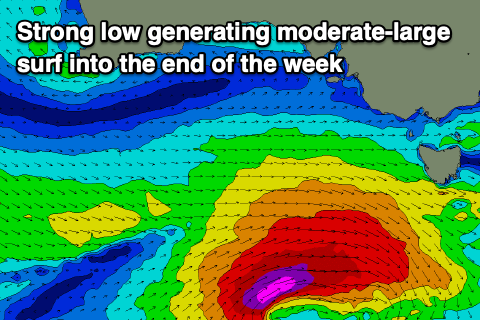
Strong swell to end the week
Southern Tasmanian Forecast by Craig Brokensha (issued Wednesday December 11th)
Best Days: Today, tomorrow, Friday morning, Saturday morning, Sunday morning
Features of the Forecast (tl;dr)
- Moderate + sized W/SW-SW groundswell tomorrow with dawn W/SW tending variable offshore winds
- Slowly easing swell Fri with N/NW-NW winds, tending fresher W/SW-SW into the PM
- Small reinforcing SW-S/SW swell Sat/Sun
- N/NW tending E/SE winds Sat, variable tending gusty S/SE Sun
Recap
The surf has hovered around the 1-2ft range the last two days with mostly favourable winds.
This week and weekend (Dec 12 - 15)
Currently a strong low has formed to our west-southwest and we’re seeing it generating a great fetch of gale to severe-gale W/SW winds through our western swell window, with the low then moving through our south-western swell window this evening.
This should produce a moderate sized W/SW tending SW groundswell for tomorrow, peaking to 4ft+ across Clifton, with the easing trend being slow. Friday should still be 3ft with trailing fetches of weak SW winds maintaining 2ft surf into Saturday/Sunday.

Local winds look a touch dicey tomorrow but should tend variable tomorrow morning after possibly being W/SW at dawn and then shifting variable N’ly into the afternoon.
Friday will also be clean with a N/NW-NW offshore ahead of a W/SW-SW change into the afternoon.
Saturday will also be clean again with a N/NW offshore ahead of sea breezes, variable Sunday morning ahead of sea breezes again.
As touched on in Monday’s notes, next week will consist of mostly tiny W/SW swell energy so with this in mind, make the most of the coming swells.

