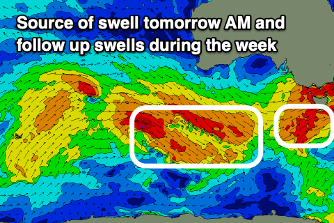
Biggest tomorrow morning with smaller swells for the week
Southern Tasmanian Forecast by Craig Brokensha (issued Monday September 2nd)
Best Days: Protected spots tomorrow, Wednesday, Thursday, Friday
Features of the Forecast (tl;dr)
- Moderate + sized, mid-period W/SW swell peaking tomorrow AM, easing with strong W/NW-W winds
- Smaller Wed with mod-fresh N/NW tending N winds
- Small W/SW swell for Thu/Fri
- Small spike of SW swell Fri PM with strong N/NW tending NW winds
- Easing swell Sat with NW winds
Recap
Saturday started around the 2ft range before pulsing late ahead of a peak in new W/SW swell Sunday to 3-4ft, easing back into this morning.
This afternoon some new energy is again on the build with sets to 3ft now being seen across Clifton with strong cross-shore W/NW winds.
This week and weekend (Sep 3 - 8)
Today’s frontal system is generating building mid-period energy, with it due to peak tomorrow morning to 3ft to occasionally 4ft across Clifton, easing into the afternoon and then smaller and to 2ft through Wednesday.
Winds will be strong out of the W/NW-W tomorrow, favouring protected spots, moderate to fresh from the N/NW tending N on Wednesday.

Continued fetches of W/NW winds have generated reinforcing, mid-period W/SW swell energy for Thursday and Friday morning to 1-2ft.
A small tight low forming south-west of us Thursday should produce a short-lived spike of SW swell for Friday afternoon to a better 2ft, fading Saturday from 1-2ft.
Strengthening N/NW tending NW winds are due on Friday as the swell builds, NW on Saturday as it eases.
Longer term, more W’ly pulses are due next week mostly in the 2ft range but we’ll have a closer look at this Wednesday.

