Tiny run of swell ahead
Southern Tasmanian Forecast by Craig Brokensha (issued Friday August 9th)
Best Days: Today
Features of the Forecast (tl;dr)
- Tiny W swell for the weekend
- Small S'ly swell possible from Thursday next week through Saturday with N-NE winds
Recap
Wednesday’s swell eased back from 1-2ft yesterday with winds varying through the day, coming up from the north at times, while this morning the swell was fading from a slower 1-1.5ft+.
This weekend and next week (Aug 10 - 16)
The west swells/winds continue this period, and the reason is outlined in this article: Stratospheric Warming Event Comes Home To Roost

As touched on in the forecasts earlier in the week, all the coming frontal activity is too far north of our swell window to generate any size at all for Clifton.
It’ll struggle to round South East Cape and with that we’re due to see a run of clean, 1ft surf from this weekend through early-mid next week.
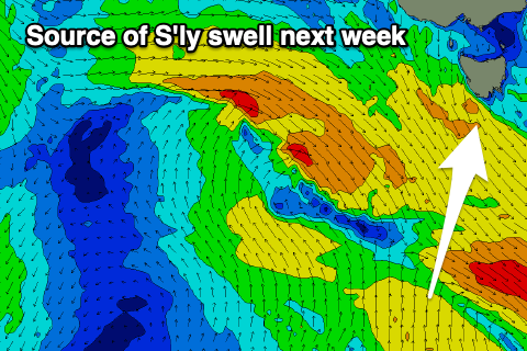
The only change to this scenario looks to be mid-late week when a polar fetch of stationary S/SW winds forms south of us, generating a small, mid-period S’ly swell for Thursday through Saturday.
We’re looking at sets to 2ft at this stage, but there’s a chance for this to be upgraded if the models go GFS’s way.
Otherwise get some chores done and wait for the next run of quality swell. Have a great weekend!

