Make the most of the coming days before swells go more west
Southern Tasmanian Forecast by Craig Brokensha (issued Monday August 5th)
Best Days: Later today, tomorrow, Wednesday, Thursday morning selected spots
Features of the Forecast (tl;dr)
- Small-mod sized W/SW swell for later today, peaking tomorrow AM, easing slowly Wed
- Moderate sized W/SW swell for Wed with
- N/NW winds Tue with W/NW-N/NW winds Wed
- Fading swell Thu with strengthening N/NE winds
Recap
The weekend but clean but tiny across the region with ideal conditions for beginners, similar today. Keep an eye out for a new pulse of mid-period W/SW swell due into this afternoon and evening.
This week and weekend (Aug 6 - 11)
The coming period looks mostly small to tiny thanks to a zonal storm track setting up through the Indian Ocean and across Australia over the coming fortnight.

With this Clifton will be mostly tiny and inconsistent, but ahead of this west swell, we’ve got some small new W/SW energy due into this afternoon and tomorrow morning. This was generated by a relatively weak but sustained low that formed to the south-southwest of Western Australia on the weekend and should provide fun 2ft+ sets across Clifton later today and tomorrow morning, easing into Wednesday.
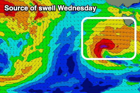
This swell will ease into Wednesday, but some new close-range W/SW swell from a strengthening front moving across us tomorrow should provide a fresh boost in size during Wednesday to 2-3ft, easing rapidly overnight with fading 1-2ft sets Thursday.
Following this, the swell generating fronts look to come in too far north of our window, sliding east-southeast through the Bight and this isn’t great for swell generation at all.
We’ll be under a constant offshore flow with this pattern though, but options for a sizey surf look tricky to none.
Check back here Wednesday for any change to the pattern.

