Good swell tomorrow spoilt by local winds
Southern Tasmanian Surf Forecast by Craig Brokensha (issued Monday October 30th)
Best Days: Wednesday morning, Thursday morning, Friday morning
Features of the Forecast (tl;dr)
- Moderate sized W/SW groundswell building tomorrow, peaking into the PM
- Strong SW winds tomorrow, possibly lighter W/SW for a short period in the AM
- Easing surf Wed with W/NW tending SW then S/SE winds
- Small reinforcing SW swell Thu PM with W/NW tending S/SE winds, easing Fri with variable tending S/SE winds
- Small background swells for the weekend with fresh S winds Sat, lighter S Sun
Recap
The swell from late last week continued to back off into Saturday with clean, 2ft waves left across Clifton, while yesterday a small, inconsistent S/SE groundswell provided mostly tiny waves to 1-2ft.
Today the small background S/SE swell was still just hanging in there, cleanest through the morning.

Full 2ft sets yesterday morning
This week and next (Oct 31 – Nov 5)
This week revolves around tomorrow's strong pulse of W/SW groundswell, with a slow moving polar low being the source.
This low has been generating a fetch of slow moving strong to gale-force winds, with a slingshot of gale to severe-gales moving on top of the active sea state.
This will produce a moderate sized pulse of W/SW groundswell for tomorrow, building to 3-4ft into the afternoon (smaller in the morning).

Unfortunately winds tomorrow are average thanks to the swell generating front clipping us, bringing a brief possible period of W-W/SW winds (very lumpy), shifting back to the SW mid-morning.
Wednesday morning looks cleaner with easing sets from 2-3ft under a W/NW offshore shifting W/SW later morning and then S/SE into the afternoon.
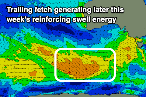
Some good reinforcing swell is due into Thursday afternoon and Friday morning, generated by trailing fetches of W/NW winds behind the strong low generating tomorrow's swell.
This should maintain 2ft surf Thursday afternoon and Friday morning, though with S/SE sea breezes, funky Friday and variable ahead of S/SE sea breezes.
The weekend will be smaller and more to 1-2ft with weaker background polar fronts stopping the South Arm from going flat.
Conditions unfortunately look dicey as a trough stalls to our north, bringing fresh S'ly winds on Saturday, lighter and more doable Sunday but we'll have a closer look at this Wednesday.
Longer term a blocking high to our west will result in the swell bottoming out through next week, so try and make the most of the coming swells.

