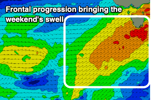
Sizey, clean swell Sunday
Southern Tasmanian Surf Forecast by Craig Brokensha (issued Friday October 13th)
Best Days: Tomorrow morning for the keen, Sunday, Tuesday morning, Thursday morning
Features of the Forecast (tl;dr)
- Low point in swell tomorrow morning with a building SW windswell into the afternoon
- Moderate W/NW winds, strengthening through the day and shifting W-W/SW
- Moderate sized mid-period SW swell for Sun AM, easing with N/NW-NW winds, variable into the PM
- Easing surf Mon with early light SW winds, strengthening from the S/SW
- Smaller Tue with N/NE tending E winds
- New SW groundswell for later Wed and Thu AM with N tending SE winds
Recap
Clean, easing S/SW swell yesterday that was ideal for beginners.
This morning a mix of new S/SW and W/SW swells pulsed to 2ft+ (a little better than the expected 1-2ft) with early light winds before onshores kicked in.
This weekend and next week (Oct 14 - 20)
We'll fall briefly in between swells tomorrow morning with 1-2ft sets due under a moderate to fresh but strengthening W/NW tending W-W/SW breeze into the afternoon.
This change and strengthening of winds will be related to a healthy polar frontal progression pushing up and across us during the day, with a fetch of strong SW winds being generated through our south-western swell window.
A late increase in windswell is due from the front tomorrow ahead of the swell proper on Sunday coming in at 4-5ft across Clifton in the morning, easing later and then down from 3ft to possibly 4ft on Monday morning.

Due to the front clearing Saturday evening, winds will tend N/NW-NW on Sunday morning creating great conditions for spots that can handle the size with variable winds into the afternoon.
Monday is dicey as a final trough/low moves across us with early light SW winds due to strengthen through the morning, shifting S/SW into the afternoon.
Tuesday looks clean again with a N/NW offshore ahead of E'ly sea breezes but smaller, easing 2ft sets.
Into Wednesday and Thursday, some new SW groundswell is due to fill in, generated by a strong but tight and not overly well structured low firing up to the south-west of us early week.
This will produce a fetch of gale to possible severe-gale W/NW winds and a fun pulse of swell Wednesday afternoon to 2-3ft, easing from a similar size Thursday morning.
The models diverge a little regarding this swell but winds look locally offshore. More on this Monday. Have a great weekend!

