Tricky period ahead with less reliable surf
Southern Tasmanian Surf Forecast by Craig Brokensha (issued Monday September 4th)
Best Days: Tomorrow ahead of sea breezes, Wednesday morning, Saturday morning
Features of the Forecast (tl;dr)
- Small, inconsistent W/SW groundswell building tomorrow, peaking in the PM with N tending S/SE winds
- Easing swell Wed with N tending N/NW winds
- Tiny Wed
- Strong S/SW winds Fri with a moderate sized + S'ly swell building
- Easing S/SE swell Sat with W/NW winds
- SW winds Sun with a possibly building swell, peaking Mon with SW winds
Recap
A fun weekend of surf with 2ft waves on Saturday, with a reinforcing pulse of energy for Sunday morning coming in at 2-3ft, easing through the day. This morning was clean but tiny.
This week and weekend (Sep 5 - 10)
The coming days will see a small, inconsistent W/SW groundswell building across the South Arm generated by a strong and too northerly positioned low, dipping south into our swell window on Friday.
It'll be inconsistent but sets to 2ft are due to develop into tomorrow afternoon, though a morning offshore is due to go sea breezy out of the S/SE as it peaks.
Wednesday morning looks smaller with easing 1-2ft sets but offshore N tending N/NW-NW winds.
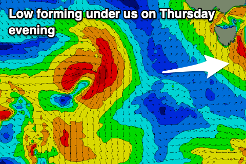
Thursday will become tiny to flat and winds will strengthen out of the N/NE thanks to an approaching trough come deepening low.

This will push across us into the evening, with strong S/SW winds due into Friday along with a jump in stormy S'ly swell.
We may see 4-5ft sets develop across Clifton through Friday, then easing out of the S/SE on Saturday from the 3-4ft range with possible W/NW winds as the low moves off to the east, pushed by a strengthening polar frontal progression.
At this stage the models diverge regarding the strength of this polar front but we may see a moderate sized pulse of SW groundswell for next Monday though winds look dicey and mostly onshore. Check back here on Wednesday for a clearer idea on next week's outlook.

