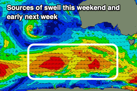
Plenty of swell inbound, with varying winds
Southern Tasmanian Surf Forecast by Craig Brokensha (issued Friday August 11th)
Best Days: Tomorrow morning, Sunday morning, Monday morning, Tuesday
Features of the Forecast (tl;dr)
- Moderate sized, mid-period W/SW swell building tomorow, holding Sun AM
- W/NW tending gusty W/SW winds tomorrow, gusty W/NW-W tending SW-S/SW Sun
- Moderate sized S/SW tending S swell building Sun PM, peaking Mon AM, then easing
- W/NW tending S winds Mon, variable tending E/NE Tue
Recap
Tiny surf the last two days, with a small lift in new mid-period W/SW swell due this afternoon.

Little runners this afternoon
This weekend and next week (Aug 12 - 18)
Later today's increase in swell and more so the weekend's energy is being generated by a healthy, elongated polar frontal progression that's currently moving in from the south-west.

The fetch has mostly been strong with a few bursts of gale-force winds, and this will see building energy tomorrow ahead of a peak into the late afternoon and Sunday morning.
Tomorrow morning should be in the 2ft range, though building to 3ft into the late afternoon and then easing from a similar size Sunday.
This easing trend will be countered by the arrival of a new S/SW swell, generated by a final front of the tail of the progression forming into a low as it passes under us tomorrow.
A great fetch of strong to sub-gale-force S/SW winds will be projected through our southern swell window, with building sets to 3ft+ due into Sunday afternoon, easing from 3-4 Monday morning and then 2-3ft Tuesday morning.

Winds will shift from the W/NW to gusty W/SW tomorrow as the low moves under us, with gusty W-W/NW winds Sunday morning before shifting SW-S/SW.
Monday looks a touch dicey but early W/NW winds are due, shifting S'ly through the day, with variable tending E/NE winds Tuesday.
Longer term we're looking at a run of tiny surf into the end of the week ahead of possible building surf next weekend. More on this Monday though. Have a great weekend!

