Plenty of swell for the coming days
Southern Tasmanian Surf Forecast by Craig Brokensha (issued Wednesday July 26th)
Best Days: Tomorrow, Friday afternoon, Saturday, Tuesday morning
Features of the Forecast (tl;dr)
- Quick spike in S/SW groundswell tomorrow AM, easing quickly through the day with N/NW tending N/NW winds
- Moderate sized mid-period SW swell building Fri, peaking later with N tending N/NW winds
- Easing surf Sat with N tending N/NW winds
- Small mix of swells Sun N/NW tending NW winds
- Moderate sized pulse of W/SW groundswell Tue with strong W/NW tending W/SW winds
Recap
Our large mix of W/SW and SW groundswells came in on forecast yesterday with thumping 5-6ft closeouts across Clifton with favourable winds for protected spots.
The swell dropped quite significantly into today back to 2-3ft.

Thumping surf yesterday (the mind boggles)
This week and next (Jul 27 – Aug 4)
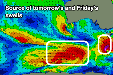
We've got a fleeting pulse of S/SW swell due tomorrow morning, generated by a late forming low south of us today.
This low is quite significant with severe-gale to storm-force core winds, but very late in our swell window.

This makes tomorrow tricky size wise, but we should see a spike overnight to 3ft, easing quickly from 2-3ft at dawn tomorrow, down to 1-2ft later.
Winds will be great and N/NW tending N/NE tomorrow with N tending NW winds on Friday along with an early low point in surf.
Into the afternoon though, a good pulse of new mid-period SW swell is due, generated by a polar front that's currently producing a great fetch of W'ly gales along the polar shelf.
We should see this kicking to 2-3ft mid-late afternoon, easing back from 2ft+ on Saturday morning.
Conditions should be clean most of Saturday with N tending N/NW winds, N/NW tending NW on Sunday but with a small mix of easing SW swell and W'ly energy to 1-2ft.
Moving into next week, a strong Southern Ocean frontal progression is due to fire up and under Western Australia, generating various fetches of gale-force W'ly winds. There's a chance that on the tail of this progression we'll see a better aligned fetch of W/SW winds in our western swell window, but for now we can expect inconsistent W/SW swell energy to peak Tuesday to 3ft+ with strong W/NW tending W/SW winds. More on this Friday.

