Fun surf days to continue
Southern Tasmanian Surf Forecast by Craig Brokensha (issued Wednesday November 17th)
Best Days: Beginners tomorrow, Saturday morning, Sunday morning, Monday morning
Features of the Forecast (tl;dr)
- Low point in swell tomorrow with N/NW tending E/NE winds
- Building SW swell Fri PM with fresh W/SW tending S/SW winds
- Peak in SW swell Sat with variable tending S/SE winds
- Easing SW swell Sun with N tending gusty E/NE winds
- Small swell Mon with N tending SW winds
Recap
Plenty of swell but with onshore winds as S/SW energy from the backside of the frontal progression linked to the cold, poor weather Monday filled in, much cleaner today and still a fun 2ft across Clifton.
This week and next (Nov 18 - 26)
We’ve got an active period of surf ahead and while not overly strong or big, there’ll be waves through until at least next weekend.
 A temporary low point is due tomorrow but conditions will be favourable for beginners with a moderate N/NW breeze, shifting E/NE into the afternoon.
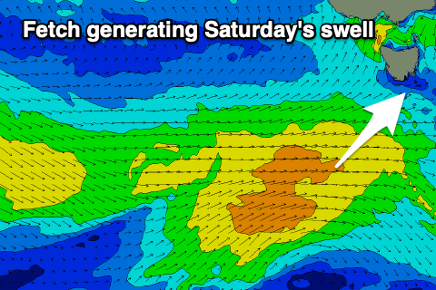
The surf will deteriorate into Friday as a swell producing front pushes in from the south-west, bringing fresh W/SW tending S/SW winds. This frontal system, while not overly strong will generate a broad fetch of W/SW winds and mid-period SW swell for Saturday that should start building Friday afternoon to 1-2ft.
Good 3ft sets are due Saturday when it peaks with slightly funky winds. We’ll hopefully see a variable breeze ahead of S/SE sea breezes, but the models are still a little misaligned. Therefore check back here on Friday for a final look at Saturday morning’s winds.
 An inland low drifting south-east across the country and intensifying north-east of us on Sunday will see N tending gusty E/NE winds develop on Sunday as the swell eases back from the 2ft range.
We may see a trailing low generating a small pulse of reinforcing SW swell Monday to 2ft or so and with light morning N’ly winds ahead of a change.
Longer term, a flurry of relatively weak but persistent fronts to the south of Western Australia early-mid next week should generate some fun W/SW swell for Friday afternoon and next weekend, but more on this in the coming updates.

