Lots of wind with building swell into early next week
Southern Tasmanian Surf Forecast by Craig Brokensha (issued Friday November 12th)
Best Days: Sunday morning, protected spots for the keen Monday, Tuesday early, Wednesday morning
Features of the Forecast (tl;dr)
- Small mid-period SW swells from today through Sun AM with onshore winds Sat, cleaner Sun with a N/NW breeze ahead of an afternoon W/SW change
- Mix of mid-period SW swell and building S/SW windswell Mon with strong W/SW tending SW winds
- Easing mix of swells Tue with fresh W/SW winds (likely W early)
- Easing surf with NW winds Wed
- New S/SW swell Fri and Sat/Sun with dicey winds
Recap
Tiny to flat yesterday while today a small pulse of swell was seen with workable, lumpy conditions. Stronger onshore winds have since moved in creating poor conditions.
This weekend and next week (Nov 13 – 19)
 The weekend should see small 1-2ft pulses of mid-period swell continuing across Clifton though winds are the main issue. A front linked to the weak swells will push through this evening with moderate to fresh S/SE tending weaker S/SW winds due in its wake.
Sunday is the pick with an offshore N/NW breeze ahead of an afternoon W/SW change and easing 1-2ft of SW swell.
Next week is much more active as a series of polar frontal systems push in through our swell window.
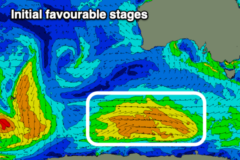
The first will generate a favourable fetch of strong W/NW winds along the polar shelf but then push unfavourably up towards South Australia, west of our swell window.
 We'll then see the frontal progression pushing across us Monday bringing some localised windswell to the mix.
The initial fetch on the polar shelf should generate 2-3ft of swell regardless, but the windswell will building to a further 3-4ft through Monday.
Winds will be poor on Monday though and strong from the W/SW-SW, shifting more SW through the day.
Tuesday may see a period of W'ly winds early (we'll confirm Monday) but with easing surf from 3ft+. Winds will otherwise be W/SW and average.
Wednesday morning will be nice and clean but easing from 1-2ft.
 Into the end of the week and next weekend some better S/SW-SW swell is due across the state, generated by a good flurry of stronger and more favourably aligned polar frontal systems pushing under the country.
Without getting into the specifics they look to be in the 3ft range Saturday/Sunday with Friday coming in around 2-3ft. The only issue are the winds with the fronts pushing up towards us, bringing generally SW breezes. More on this Monday though. Have a great weekend!

