Solid but onshore tomorrow, fun from Sunday
Southern Tasmanian Surf Forecast by Craig Brokensha (issued Friday September 24th)
Best Days: Sunday, Monday morning, Tuesday morning, selected spots Wednesday and Thursday
Features of the Forecast (tl;dr)
- Moderate sized mix of W/SW groundswell and mid-period SW swell tomorrow with strong W/SW tending SW winds
- Easing mix of swells Sun with light N/NW winds ahead of weak sea breezes
- Smaller Mon with N/NW tending S/SW winds
- Fun mid-period SW swell Tue with N/NW tending S/SE winds
- Continuing pulses of mid-period swell Wed-Thu with E/NE-NE winds
Recap
A solid, clean 3-4ft wave on the coast yesterday morning, building even further during the day as winds turned more W'ly, favouring protected spots. This morning the swell has dropped back to 3-4ft and conditions were best early ahead of strengthening winds which will shift W'ly again as a vigorous cold front pushes across us.
This weekend and next week (Sep 25 – Oct 1)
We're not done with this large swell yet, with the final, strong and strengthening low linked to a great frontal progression this week, now moving in and across us.
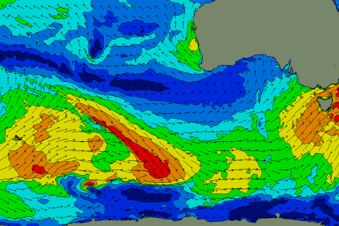
A fetch of gale to severe-gale W/SW winds are being projected through our western swell window, with the low moving across us this evening, leaving weaker, SW winds in our swell window (below right).
 This will produce a moderate sized mix of W/SW groundswell and mid-period SW swell for tomorrow, coming in around the 4ft range but with strong W/SW tending SW winds and cold weather.
Sunday is a much better day to surf with a lighter NW offshore and easing 2-3ft surf, with weak sea breezes due into the afternoon.
Monday morning will be clean but smaller and to 1-2ft.
Moving into Tuesday and a fun, new mid-period SW swell is due, generated by a relatively weak but elongated polar front moving in from the west on the weekend (shown right, under the country and to the SW of WA). A fetch of strong W/NW winds should produce 2ft+ surf on Tuesday, while some secondary, weaker activity projecting into us Monday. This might help push the odd set to 3ft but expect size mostly below this.
Winds should be OK and light N/NW with a trough possibly bringing an onshore change, but we'll confirm this Monday.
Longer term, persistent polar frontal activity looks to maintain 2ft+ surf through the rest of the week though will less favourable E/NE-NE winds. More on this Monday. Have a great weekend!

