Ranging surf from small to large
Southern Tasmania Surf Forecast by Craig Brokensha (issued Monday 13th April)
Best Days: Tuesday, Wednesday, Thursday morning, Friday, Saturday, Sunday
Recap
Bumpy and with a good kick in new swell on Saturday, cleaner yesterday morning and back to 2ft.
Today a new S/SW groundswell should be offering solid waves across Clifton, reaching 3ft to occasionally 4ft as it peaks this afternoon.
This week and weekend (Apr 14 - 19)
We'll see today's swell easing back through tomorrow from 3ft on the sets tomorrow, though mostly 2-3ft, smaller Wednesday mixed in with some S/SE swell to 1ft to possibly 2ft.
Conditions will be clean most of tomorrow with N'ly offshores, tending variable ahead of possible late sea breezes, N/NW tending NE winds Wednesday.
 The models are showing a better pulse of S/SE groundswell for Thursday, but the low generating this will form south of WA and the fetch will be more north in alignment compared to north-west, limiting the expected size across Clifton. We're likely to see lingering inconsistent 1-2ft sets Thursday with W-W/NW winds.
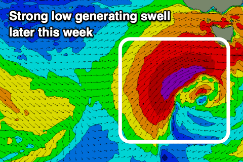
Moving into later week there's a bit of swell on the way with a strong frontal progression due to move in initially north of our swell window, followed by a stronger and more southerly positioned low directly south-west of us.
This low is forecast to develop Thursday evening, with a fetch of severe-gale to storm-force W/SW-SW winds due to be projected up and into the south of the state during Friday. The low will be slow moving with it continuing to impact us Saturday before pushing north-east into the afternoon.
Size wise we're looking at building surf to 4-5ft or so later Friday with a peak Saturday morning to a bumpy 6ft. Winds on Friday as the swell builds look favourable and out of the W/NW, poor Saturday and W/SW. Sunday will become cleaner as the swell eases, but more on this Wednesday.

