No end in sight to the run of poor surf
Southern Tasmania Surf Forecast by Craig Brokensha (issued Friday 14th February)
Best Days: No good days, beginners Monday morning
Recap
Tiny waves continued yesterday, similar today with better waves further afield.
This week and weekend (Feb 15 - 21)
There's nothing of note for the weekend with onshore winds and tiny surf tomorrow, windswelly on Sunday. Monday should see winds swing around to the NE through the morning with an easing SE windswell from maybe 1-1.5ft. Not ideal.
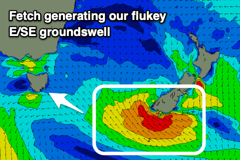
We then look to our E/SE groundswell through next week and currently Tropical Cyclone Uesi is dropping south through the Tasman Sea bringing large surf to the entire East Coast.
 Uesi will drop towards New Zealand and aim a short-lived fetch of E/SE gales on the edge of our swell Sunday evening and Monday morning.
The swell is due to build Tuesday afternoon and peak Wednesday morning to 2ft+ across Clifton if we're lucky. Remember again this is a tricky swell source but spots further down the South Arm will see more size.
Unfortunately SE sea breezes will create bumpy conditions Tuesday afternoon, with fresh S/SE winds on Wednesday, spoiling the peak of the swell.
Following this unfortunately there's still nothing major on the cards so again check the East Coast Forecaster notes for more options. Have a great weekend!

