Large swell for the weekend, plenty more swell next week
Southern Tasmania Surf Forecast by Craig Brokensha (issued Friday 10th January)
Best Days: Protected spots later tomorrow, Sunday, Monday, Tuesday morning, Wednesday
Recap
Inconsistent and only tiny, easing 1-1.5ft waves yesterday, near flat today and with a NE wind.
This weekend and next week (Jan 11 - 17)
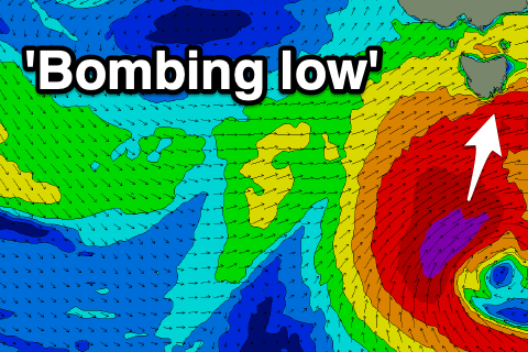
Currently, a 'bombing low' is forming south-southwest of the state, with it dropping more than 24hPa in central pressure in a period of 24 hours
With such a rapid intensification a large pressure gradient is set up between the low and a strong high in the Bight, resulting in the formation of a severe-gale to storm-force fetch of SW-S/SW winds in our swell window.
Building and strengthening levels of mid-period and groundswell are due tomorrow out of the SW, ahead of a peak in S/SW groundswell on Sunday.
 Looking at the size, Clifton should build to an easy 4ft into the late afternoon and evening, with the S/SW groundswell Sunday still expected to peak around 4-6ft, easing later in the day and further from 3-5ft or so Monday morning.
Winds on the weekend will be best for protected spots and out of the W/SW and strong tomorrow, W/NW Sunday morning, shifting SW ahead of S/SE sea breezes. Monday then looks nice with NNE offshores ahead of E/SE sea breezes.
Tuesday should provide fun waves, easing back from 2ft to maybe 3ft ahead of a new W/SW groundswell late in the day and more so Wednesday.
The source of this swell will be a tropical depression being absorbed into the westerly storm track, resulting in the intensification of a polar front. A low is due to form, generating a fetch of W/SW gales in our western swell window.
The swell from this storm looks good, peaking around a good 3ft across Clifton Wednesday though winds look to be N/NE. We'll have to review and confirm this on Monday. Have a great weekend!


Comments
Great sat image of the 'bombing low'.