Tricky and fleeting pulses of swell this period
Southern Tasmania Surf Forecast by Craig Brokensha (issued Wednesday 31st July)
Best Days: Possibly dark tomorrow protected spots, Friday, Sunday, Monday, Tuesday
Recap
A solid S/SW groundswell and good winds for protected spots yesterday with small runners, cleaner this morning as the S'ly swell persisted at a good 3ft.
Today’s Forecaster Notes are brought to you by Rip Curl
This week and next (Aug 4 - 9)
Our currently S'ly swell will continue to ease this afternoon, leaving small to tiny waves tomorrow morning ahead of a late spike in new SW groundswell.
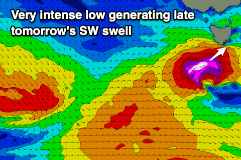
This swell has been upgraded since Monday's update, with a very tight and intense low forecast to develop in our swell window, south-west of us early tomorrow morning.
 A real short and brief fetch of severe-gale to storm-force W/SW winds are forecast to be projected through our swell window, with the swell building rapidly tomorrow afternoon and likely reaching 4-5ft by dark across Clifton but with early W/NW tending gusty W/SW winds, persisting until dark.
The swell will drop rapidly into Friday from 3ft to maybe 4ft, mixed in with some background W/SW and SW swells. Winds will improve and swing back to the N/NW on Friday, shifting W/NW into the afternoon.
We then look at the broad and strong polar frontal progression forecast for the weekend and it's now looking like all the main storm activity will occur a little further east than ideal, resulting in moderate pulses of S/SW groundswell instead of large pulses. There's a reinforcing S'ly groundswell for early next week that may provide the most size.
Firstly though we'll see a pre-frontal fetch of W/NW gales generating a new W/SW groundswell for Saturday morning to 2-3ft, with a trailing fetch of strong to gale-force SW winds due to produce a new S/SW groundswell for late in the day but more so Sunday morning to 3-4ft across Clifton.
 This is expected to ease slowly through the day, smaller into Monday and easing from 2ft+.
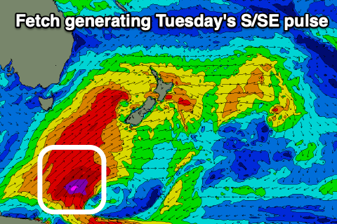
As the progression sits east of us, a final burst of severe-gale to storm-force S/SW winds on the edge of our swell window on Sunday morning should produce a good S/SE groundswell for Tuesday to the 4ft range, easing slowly through the day and down further from 2-3ft on Wednesday.
Coming back to the local winds, and Saturday will be onshore from the SW tending W/SW with the mix of new swells, much better Sunday with a W/NW tending variable breeze.
Monday will see persistent N/NW winds, with Tuesday offering N/NW tending W/NW breezes with the good easing S/SE groundswell. Longer term there's a bit of frontal activity due into the middle to end of next week, but more on this Friday.

