Small westerly swells to continue
Southern Tasmania Surf Forecast by Craig Brokensha (issued Monday 15th July)
Best Days: Thursday morning, early Friday, Saturday beginners, later Sunday, Monday morning
Recap
A new W/SW groundswell yesterday to 2ft in the morning, building into the late afternoon and this morning coming in at a fun 2-3ft. Conditions have been great all day as the swell dropped.
Today’s Forecaster Notes are brought to you by Rip Curl
This week and weekend (Jul 25 – 28)
This morning's swell is expected to drop further into tomorrow morning, easing from 1-2ft across Clifton with offshore N/NW winds.
We've got a small reinforcing W/SW swell due Friday but with it being generated by a less than favourably aligned pre-frontal fetch of W/NW gales, a continuation of inconsistent 1-2ft surf is due across Clifton. Also winds look tricky as a change moves through around dawn, but we'll hopefully see a morning W/NW breeze, shifting W/SW through the morning.
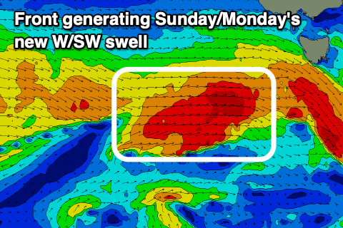
 Saturday looks to be on the tiny side, though clean and great for beginners, with a mix of new W/SW swells building Sunday. The best will be produced by a strengthening front moving in from the west on the weekend, projecting a fetch of W/SW gales through our western swell window.
Building surf from 1-1.5ft to 2ft+ later in the day is due on Sunday, easing from 2ft Monday. Winds look favourable and offshore all day Sunday from the W/NW and then NW Monday morning ahead of a S'ly change owing to a surface trough moving through.
Following the trough, onshore S'ly winds are due along with an increase in mid-period S/SE swell, easing Wednesday with hopefully better conditions.
After this we've got some inconsistent long-range W/SW groundswell on the cards, but more on this Friday.

