Multiple westerly swells inbound
Southern Tasmania Surf Forecast by Craig Brokensha (issued Wednesday 17th July)
Best Days: Tuesday afternoon, Wednesday, Thursday, dawn Friday, Sunday
Recap
A small fun swell to 1-2ft on Saturday with clean conditions, dropping back a bit into yesterday and tiny today.
Today’s Forecaster Notes are brought to you by Rip Curl
This week and weekend (Jul 23 – 28)
We've got a good mix of swells due over the next two days, the best pulse likely coming in Wednesday.
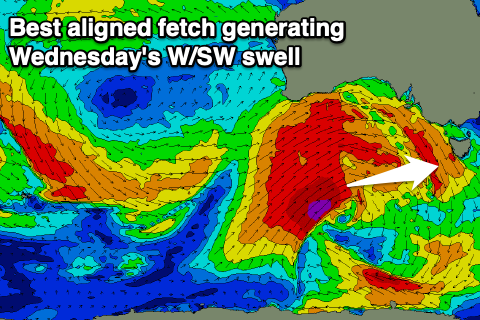
A significant frontal progression firing up south-west of WA has been generating fetches of severe-gale to storm-force W'ly winds just within our western swell window.
The progression is currently south of WA and still generating a good fetch of severe-gale W/SW winds better positioned in our swell window, and this will be the source of Wednesday's pulse.
 Firstly tomorrow though we'll be starting from a small 1ft to maybe 2ft, with the W/SW groundswell building into the afternoon and reaching 2-3ft on the sets by late, better and more consistent on Wednesday to 3ft, easing into the afternoon and then down to 1-2ft on Thursday morning.
Conditions will be great through this period with a N/NW tending W/NW breeze later tomorrow, W/NW tending N/NW breeze Wednesday and N/NW winds Thursday.
A new reinforcing W'ly swell is due on Friday, produced by a fetch of W/NW gales moving in under WA tomorrow. This should keep small and inconsistent 1-2ft waves hitting Clifton into Friday, dropping Saturday ahead of a similar sized W/SW groundswell pulse on Sunday.
The source of this will be another pre-frontal W/NW fetch of gales and sets to 2ft are likely again across Clifton.
Winds on Friday will swing onshore mid-morning creating bumpy conditions, clean all weekend with persistent N/NW offshores.
Longer term there's nothing too significant on the cards, so make the most of the coming swells.

